 |
Ponderosa Pine Scenic Byway near
Diversion Dam |
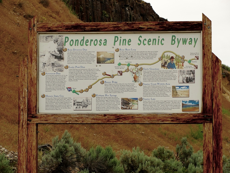
The Ponderosa Pine Scenic Byway is one of the most scenic and diversified byways imaginable. It has urban elements at one end, large reservoirs, mining towns, mountain passes, beautiful timber and mountain ranges, rivers, peaceful valleys and the majestic Sawtooth mountains at the other end. There are many ways to fit this byway into an
Idaho vacation.
The byway blog is being split into three parts - Part 1
Boise to
Idaho City is here, Part 2 covers Idaho City to Lowman, and Part 3 covers Lowman to
Stanley. Be sure to read all three parts to get information on the entire byway.
 |
| Remnants of Lowman Fire |
 |
Kirkham Hot Spring Along the Middle Fork
Payette River |
Highway ID-21 from Lowman follows the
Middle Fork Payette River. The most popular whitewater rafting/kayaking activities are downriver from here. We pass miles of fire burned landscape and begin to appreciate the powerful forces at work in shaping and molding the forest world around us. Nature is wonderful at revegatating the burned landscape. We pass several campgrounds, some with
hot springs and soaking pools. Check with
Boise National Forest for specific campground information. A few commercial outlets are available to provide gas and nourishment along this area.
 |
Historic Sign for Emile Grandjean,
Early Forest Ranger |
Before long we arrive at the turnoff for Grandjean, an area named for Emile Grandjean, an early Forest Ranger and environmentalist. A road leads past summer homes to Sawtooth Lodge and on to Grandjean campground. Trailheads from here access the western side of the Sawtooth National Recreational Area and the Sawtooth Wilderness Area.
 |
| View of Sawtooth Wilderness Area from Grandjean Overlook |
Back on ID-21, don't miss the scenic overlook a few miles east of the Grandjean Road junction. This is really the first unobstructed view of the majestic Sawtooth Mountain Range.
Our highway now turns mostly north and rapidly gains elevation as we head towards the top of Banner Summit. We have left the river behind and now gain serious elevation as the mountains rise sharply on both sides of the highway. During winter months, this stretch is very prone to avalanches and the highway is frequently closed. Winter travel should always include a check with the highway department before heading on this stretch of road. The area is beautiful but give it plenty of respect.
 |
| Fishing Dock at Martin Lake |
From the top of Banner Summit the road is now downhill all the way to
Stanley. We are starting the last major leg of this
Idaho scenic byway. Just a mile past the summit, a dirt road leads left to the popular fishing and camping areas of
Bull Trout Lake and the nearby
Martin Lake. These areas have nice camping facilities and access to the lakes which are stocked with rainbow trout.
Martin Lake even has a dock protruding into the lake for handicap fishing.
A couple miles farther along our road is the junction of FR 579, an access to the popular
Dagger Falls and Boundry Creek, the major putin for floating the Middle Fork Salmon River. Also accessible from this road is the
Bear Valley and Johnson Creek drainages. This is also a popular access to
Deadwood River and Reservoir. One can also cut through forest to Landmark,
Warm Lake and on to US-55 at Cascade. Have access to good maps before venturing this route.
 |
Stanley Lake With McGowen
Peak in Background |
Our road reaches its most northern point as it rounds Cape Horn before beginning a mostly gentle downgrade to the southeast and Stanley. We pass more picnic areas, campgrounds and wildlife viewing areas as we enter the Sawtooth National Recreational Area. Valley Creek is to the north of the highway and the rugged
Sawtooth Mountains to the south.
This trip would not be complete without a stop at
Stanley Lake, a few miles before arriving in
Stanley. This beautiful blue water lake is backed by
McGowen Peak. Several campgrounds are near the lake shore. Trails lead into the backcountry.
 |
| View of Sawtooth Mountains West of Stanley, Late June |
The majestic Sawtooth peaks gradually come into better view as we near
Stanley. This has to be the very heart of the most beautiful part of the state in my opinion.
Stanley is the end point for the Ponderosa Pine Scenic Byway.
 |
Sawtooth Mountains West of Stanley
Late June |
Our byway today has taken us from the
Boise River over a major pass to the
Middle Fork Payette River then over another major pass to the
Salmon River.
Be prepared - one cannot travel by road from
Stanley without traveling on a scenic byway. One of the other two roads from
Stanley leads to the south through
Sun Valley back towards
Twin Falls on the Sawtooth Scenic Byway and the other goes down the
Salmon River towards Challis, Salmon and the
Montana border on the Salmon River Scenic Byway.
Additional Information Sources:
Guide to Idaho's Scenic Byways - http://www.idahobyways.gov/, Idaho Division of Tourism Development,
700 West State Street, P.O. Box 83720, Boise, ID 83720-0093, Phone: (208) 334-2470
Boise National Forest -
1249 S. Vinnell Way, Suite 200, Boise, ID 83709, (208) 373-4100,
rr4boiseinfo@fs.fed.us, http://fs.usda.gov/boise
Sawtooth National Forest - 2647 Kimberly Road East, Twin Falls, ID 83301, (208)737-3200, http://fs.usda.gov/sawtooth
Sawtooth National Recreational Area - Information is through the Sawtooth National Forest, SNRA Headquarters phone is (208)727-5000, the latest Recreation Report is here.
Stanley, Idaho - Chamber of Commerce, PO 8, Stanley, ID 83278,(208)774-3411, http://www.stanleycc.org/, email information@stanleycc.org


No comments:
Post a Comment