This post will be short and sweet. The Sun Valley Film Festival would make a great late winter Idaho vacation. Where better to spend a few days than the world famous Sun Valley area?
Sun Valley boasts of being the first destination ski resort and continues to be one of the best today.
There are a multitude of lodging, and dining options, and unlimited indoor and outdoor activities.
Enjoy skiing, ice skating, and many other outdoor activities then relax at the theatre watching the "cutting edge independent films, premieres, exciting children's programming and previews of new television and web series."
Film makers from around the world will be presenting their work in this festival which has a long tradition of excellence.
The dates for 2012 are March 15-18. Full information on the Film Festival can be found here.
More Sun Valley information is here.
Click here for information on Ketchum.
The Ketchum/Sun Valley area is located about mid-way along the Sawtooth Scenic Byway which begins at Shoshone, 55 miles to the south. The northern end point of the byway is at Stanley, 61 miles farther north. This US-93 highway route is beautiful any time of the year but is especially beautiful in the winter months.
Byway information is here and here.
Showing posts with label Southcentral. Show all posts
Showing posts with label Southcentral. Show all posts
Sunday, January 22, 2012


Tuesday, January 10, 2012
Idaho Vacation: Twin Falls Centennial Waterfront Park
Twin Falls is a city with many very nice parks. Centennial Park,just north of the city, ranks as one of the nicest in the area. This makes a great place to take a quick Idaho vacation or just spend a few quiet hours enjoying the beauty of the Snake River canyon.
Centennial Waterfront Park is actually a Twin Falls County Park located less than a mile from the south end of Perrine Bridge which spans the Snake River Canyon. Canyon Springs Road heads west along the canyon wall towards the park and Canyon Springs Golf Course.
The park was developed in 1990 and boasts lots of grass, picnic areas, playground, hiking trails, waterfront activities, rock climbing and much more. The scenery is fantastic with great views of Perrine Bridge, the Snake River, and waterfalls tumbling down the canyon walls. When we visited in January, beautiful ice formations were bountiful along the canyon road.
Just down the road a bit from the park entrance is Canyon Springs Golf Course, an 18-hole public course.
This area is close to the better known Shoshone Falls (blog post here). While in the area, stop at the Perrine Bridge Visitors Center to get fantastic views of the Snake River Canyon and the famous Perrine Bridge (over 1500 feet long and about 500 feet above the Snake River). This area is just four miles south of I-84 and very much worth the short detour. The Magic Valley Mall is just across US-93 from the turnoff to the park.
Take a break and enjoy this part of your Idaho Vacation.
Additional Information:
Twin Falls Chamber of Commerce - http://twinfallschamber.com/
South Central Idaho Tourism - http://visitsouthidaho.com/cake/
 |
| Sign at Entrance to Centennial Waterfront Park |
 |
| Centennial Park with Perrine Bridge in Background |
 |
| Picnic area at Centennial Waterfront Park |
 |
| Small Waterfall and Icicles Along Snake River Canyon Wall, View From Centennial Waterfront Park |
Just down the road a bit from the park entrance is Canyon Springs Golf Course, an 18-hole public course.
 |
| Some of the Playground Equipment at Centennial Waterfront Park |
 |
| Covered Pavillion at Centennial Waterfront Park |
 |
| Perrine Bridge Over Snake River, View From Centennial Waterfront Park Hiking Trail |
Take a break and enjoy this part of your Idaho Vacation.
Additional Information:
Twin Falls Chamber of Commerce - http://twinfallschamber.com/
South Central Idaho Tourism - http://visitsouthidaho.com/cake/
Wednesday, September 21, 2011
Idaho Vacation: Ponderosa Pine Scenic Byway, Part 3 Lowman to Stanley
The Ponderosa Pine Scenic Byway is one of the most scenic and diversified byways imaginable. It has urban elements at one end, large reservoirs, mining towns, mountain passes, beautiful timber and mountain ranges, rivers, peaceful valleys and the majestic Sawtooth mountains at the other end. There are many ways to fit this byway into an Idaho
The byway blog is being split into three parts - Part 1Boise Idaho City is here , Part 2 covers Idaho Stanley
Before long we arrive at the turnoff for Grandjean, an area named for Emile Grandjean, an early Forest Ranger and environmentalist. A road leads past summer homes to Sawtooth Lodge and on to Grandjean campground. Trailheads from here access the western side of the Sawtooth National Recreational Area and the Sawtooth Wilderness Area.
Back on ID-21, don't miss the scenic overlook a few miles east of the Grandjean Road junction. This is really the first unobstructed view of the majestic Sawtooth Mountain Range.
Our highway now turns mostly north and rapidly gains elevation as we head towards the top of Banner Summit. We have left the river behind and now gain serious elevation as the mountains rise sharply on both sides of the highway. During winter months, this stretch is very prone to avalanches and the highway is frequently closed. Winter travel should always include a check with the highway department before heading on this stretch of road. The area is beautiful but give it plenty of respect.
From the top of Banner Summit the road is now downhill all the way to Stanley Idaho Bull Trout Lake Martin Lake Martin Lake
A couple miles farther along our road is the junction of FR 579, an access to the popularDagger Falls Bear Valley Deadwood River Warm Lake
Our road reaches its most northern point as it rounds Cape Horn before beginning a mostly gentle downgrade to the southeast and Stanley. We pass more picnic areas, campgrounds and wildlife viewing areas as we enter the Sawtooth National Recreational Area. Valley Creek is to the north of the highway and the rugged Sawtooth Mountains
This trip would not be complete without a stop atStanley Lake Stanley McGowen Peak
The majestic Sawtooth peaks gradually come into better view as we near Stanley Stanley
Our byway today has taken us from the Boise River Middle Fork Payette River Salmon River .
Be prepared - one cannot travel by road fromStanley Stanley Sun Valley back towards Twin Falls Salmon River towards Challis, Salmon and the Montana
Additional Information Sources:
Guide toIdaho
700 West State Street, P.O. Box 83720 , Boise , ID 83720-0093 , Phone: (208) 334-2470
Boise National Forest
1249 S. Vinnell Way, Suite 200 , Boise , ID 83709 , (208) 373-4100,
rr4boiseinfo@fs.fed.us, http://fs.usda.gov/boise
Sawtooth National Forest - 2647 Kimberly Road East, Twin Falls, ID 83301, (208)737-3200, http://fs.usda.gov/sawtooth
Sawtooth National Recreational Area - Information is through the Sawtooth National Forest, SNRA Headquarters phone is (208)727-5000, the latest Recreation Report is here.
Stanley, Idaho - Chamber of Commerce, PO 8, Stanley, ID 83278,(208)774-3411, http://www.stanleycc.org/, email information@stanleycc.org
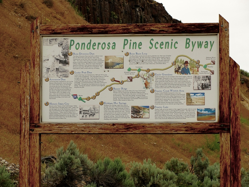 |
| Ponderosa Pine Scenic Byway near Diversion Dam |
The byway blog is being split into three parts - Part 1
 |
| Remnants of Lowman Fire |
 |
| Kirkham Hot Spring Along the Middle Fork Payette River |
Highway ID-21 from Lowman follows the Middle Fork Payette River hot springs Boise National Forest
 |
| Historic Sign for Emile Grandjean, Early Forest Ranger |
 |
| View of Sawtooth Wilderness Area from Grandjean Overlook |
Our highway now turns mostly north and rapidly gains elevation as we head towards the top of Banner Summit. We have left the river behind and now gain serious elevation as the mountains rise sharply on both sides of the highway. During winter months, this stretch is very prone to avalanches and the highway is frequently closed. Winter travel should always include a check with the highway department before heading on this stretch of road. The area is beautiful but give it plenty of respect.
 |
| Fishing Dock at Martin Lake |
A couple miles farther along our road is the junction of FR 579, an access to the popular
 |
| Stanley Lake With McGowen Peak in Background |
This trip would not be complete without a stop at
 |
| View of Sawtooth Mountains West of Stanley, Late June |
 |
| Sawtooth Mountains West of Stanley Late June |
Be prepared - one cannot travel by road from
Additional Information Sources:
Guide to
rr4boiseinfo@fs.fed.us, http://fs.usda.gov/boise
Sawtooth National Forest - 2647 Kimberly Road East, Twin Falls, ID 83301, (208)737-3200, http://fs.usda.gov/sawtooth
Sawtooth National Recreational Area - Information is through the Sawtooth National Forest, SNRA Headquarters phone is (208)727-5000, the latest Recreation Report is here.
Stanley, Idaho - Chamber of Commerce, PO 8, Stanley, ID 83278,(208)774-3411, http://www.stanleycc.org/, email information@stanleycc.org
Monday, August 29, 2011
Idaho Vacation: Malad Gorge State Park
Malad Gorge State Park is just one mile off of I-84 but most travelers do not know it is there. As you travel on your Idaho vacation, make this a stop for impressive canyon views and a beautiful grassy area with picnic tables and rest rooms for a mid-day picnic. Younger travelers will appreciate the opportunity to stretch their legs and play on the playground equipment before getting back in the car.
The Malad River is only about 12 miles long and is formed when the Big Wood River and Little Wood Rivers join near Gooding. The Malad River drains into The Snake River. From this overlook, there is no trail to the bottom of the gorge.
The other units of the Thousand Springs State Park include:
Billingsley Creek -
Vardis Fisher -
Ritter Island -
Earl M Hardy Box Canyon Springs -
Niagara Springs -
Click here for descriptions of all six units.
Click here for a nice area map showing all six units.
More information about Idaho State Parks is found on the Idaho State Parks web pages - http://parksandrecreation.idaho.gov/parks or contact them at PO Box 83720, Boise, ID 83720, 888-922-6743.
The fee to enter Idaho State Parks is $5.00/day, season passes are available.
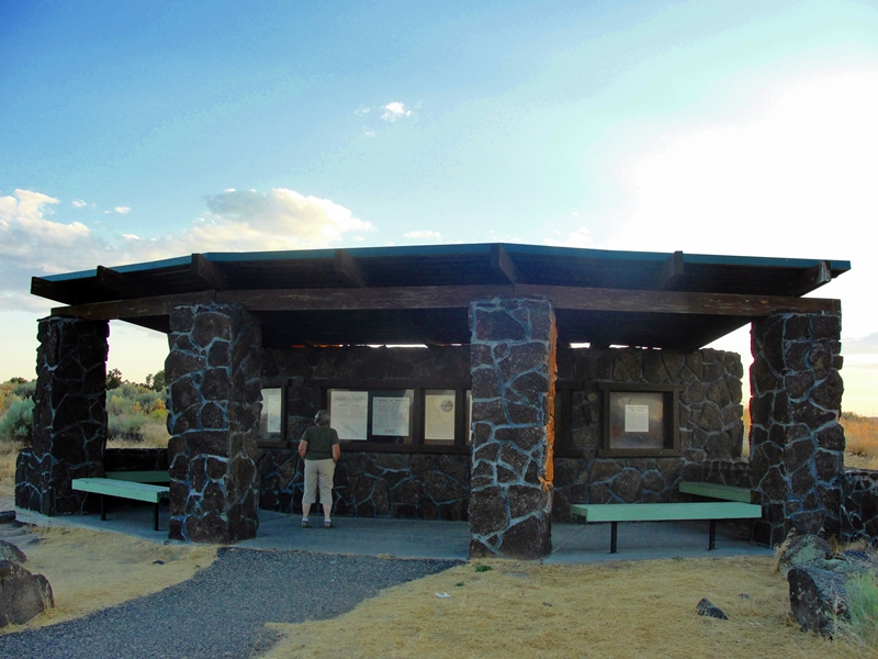 |
| Interpertative Center At Malad Gorge State Park |
 |
| Looking Upstream from Overlook Footbridge at Malad Gorge State Park |
Malad Gorge is one of six units that comprise the Thousand Springs State Park. It is the only unit directly accessible from I-84. The park is 652 acres and has hiking trails as well as a nice interpretative center near the canyon overlook. The picnic tables, playground, shade trees and restrooms are separated from the overlook but only a quarter mile or so away. Camping is not allowed in the park but private campgrounds are located nearby.
 |
| Covered picnic Tables and Grass Playground at Malad Gorge State Park |
To acccess the park, take I-84 exit 147 (Tuttle exit) and proceed north and west one mile to the canyon overlook. A sturdy footbridge crosses the canyon for excellent views of the river crashing over boulders approximately 175 feet below. The footbridge is very close to the highway bridge. From the footbridge, one can look upstream at the staircase rapids. Immediately under the bridge is Devils Washbowl, a large basin of wild water. Looking downriver, the gorge deepens to over 250 feet as the river flows toward its confluence with the Snake River just 2 1/2 miles away.
 |
| Malad River Flows Through 250 Ft Deep Gorge at Malad Gorge State Park |
Just a 1/4 mile upstream from the footbridge, is Kelton Crossing. This was the bridge over the canyon where the Oregon Trail crossed the gorge. Fortunately the canyon was narrow at this place and only 35-40 feet deep. This bridge on the Kelton Road carried wagons, freight, passengers, mail, and everything else on the Oregon Train from about 1864 - 1883 when the railroad was built through the area.
The Malad River is only about 12 miles long and is formed when the Big Wood River and Little Wood Rivers join near Gooding. The Malad River drains into The Snake River. From this overlook, there is no trail to the bottom of the gorge.
 |
| Malad River Flows into Devils Washbowl Photo is Looking Straight Down From Footbridge |
Billingsley Creek -
Vardis Fisher -
Ritter Island -
Earl M Hardy Box Canyon Springs -
Niagara Springs -
Click here for descriptions of all six units.
Click here for a nice area map showing all six units.
 |
| Sunset , View From Malad Gorge State Park |
The fee to enter Idaho State Parks is $5.00/day, season passes are available.
Saturday, July 2, 2011
Idaho Vacation: Atlanta, An Idaho Mining Town
Atlanta is located near the headwaters of the Middle Fork of the Boise River and sits at an elevation of 5383 feet. It is located approximately 80 miles east of Boise. There is one road in and out of Atlanta but several forks down river allow an approach from different directions. All roads leading to Atlanta are closed seasonally.
The roads are the biggest problem in getting access to Atlanta. They are all dirt and gravel and generally washboardy rough. I would not recommend taking large travel trailers or motorhomes on this drive unless you are planning a relatively long stay.
Active significant commercial mining has not taken place in the Atlanta basin for over 50 years but recent efforts may change that as mining permits have been filed and are being evaluated for environmental impact. Recreational and small scale mining, especially in the rivers and streams continues every year.
Atlanta overlooks the Middle Fork of the Boise River and beautiful Graylock mountain to the north. There are numerous buildings that date back to turn of the century or earlier construction.
Forest Service campgrounds near Atlanta and downriver provide beautiful settings for outdoor recreation adventures. We camped at the Riverside Campground and had a wonderful site adjacent to the Middle Fork. An Osprey nest in a tall dead tree in the campground had three young chicks. There are also numerous hot springs near Atlanta. The area is popular for hiking, backpacking, hunting (in season), fishing and various other forms of outdoor activity. This area was made for back-country outdoor activities.
Abandoned cabins, mine machinery, and a city power plant bear testimony of the thriving community of yesteryear. Surprisingly, recent building activity is evident as is modern street signs. One has the feeling that the individuals living in Atlanta are fiercely independent, not existing for corporate convenience. This is a refreshing place to visit.
I’ll describe three approaches to Atlanta, all of which are washboardy dirt roads. Don’t be in a hurry while traveling these routes. Your reward is beautiful scenery frequented by wildlife and much of it along the beautiful Middle Fork of the Boise River. The first approach leaves Boise and exits I-84 at Gowen Road/Idaho City (exit 57). Travel towards Idaho City on ID-21 about 13 miles to the intersection with NF-268, turn right and follow this road about 67 miles to Atlanta. The road is paved until arriving at Arrowrock Reservoir.
Around the reservoir, the road climbs quite high above the reservoir and is narrow and crooked. Use caution on this stretch! Before arriving in Atlanta, the road changes to NF-377. This route follows the Middle Fork all the way from Arrowrock Reservoir.
The second approach starts the same as described above but continue on ID-21 past Idaho City another 22 or so miles to the Crooked River road NF-384. Turn onto NF-348 and follow this road to the North Fork of the Boise River road. Continue straight on NF-327 (Swanholm Creek Road) to the Middle Fork Road (NF-377), turn left and proceed as above to Atlanta. According to internet maps, this route is about 10 miles longer, has more paved road, and is slightly faster to travel. In addition you avoid the narrow, high, and very crooked road above Arrowrock Reservoir.
The third route is completely different except for the last 3-4 miles. Starting from Mountain Home, take I-84 exit 90 and travel NE towards Fairfield on US-20 approximately 30 miles. Turn left onto Louse Creek Road (FR-181) and travel generally north towards Pine and Featherville. In Featherville, take FR-156 to Rocky Bar (another mining almost ghost town) then turn onto FR-126 towards James Creek and the Middle Fork Road. Turn right onto the Middle fork Road and continue to Atlanta. This route takes you across sagebrush flats, the Bennet foothills, and by Anderson Ranch Reservoir.
The trip into Atlanta and back can be made in one day but I recommend at least two days so the drive and area can be fully enjoyed. When we were last there in 2010, there were no commercial lodging facilities. Be prepared with your own facilities. In many ways, the drive is a pain but the scenery and living history lessons available in and around Atlanta are worth the effort.
More information on Atlanta can be found here and here. Boise National Forest campground information is here for Powerplant, here for Riverside, and here for Queen's River, the three closest campgrounds to Atlanta.
Make this an Idaho vacation that will last in memory for a long long time.
 |
| Building in Atlanta |
Take a step back in time, Atlanta, an 1860’s vibrant mining town, is not a ghost town but almost so. This is as close as one can get to a real living outdoor town museum. There is much to do and see in and around Atlanta, make it part of your plans for an Idaho vacation.
 |
| Atlanta Artist Finishing a Bear in a Barrel Sculpture |
Atlanta, supposedly named after the famous Civil War battle of Atlanta, Georgia, was settled after gold and silver were found in the area in 1863-64. John Stanley discovered gold in the Yuba River, just a few miles downstream from Atlanta. Later in 1864, John Simmons discovered the Atlanta lode, bearing both gold and silver.
 |
| Abondened Cabin, Atlanta |
The roads are the biggest problem in getting access to Atlanta. They are all dirt and gravel and generally washboardy rough. I would not recommend taking large travel trailers or motorhomes on this drive unless you are planning a relatively long stay.
 |
| Abondened Mine and Equipment, Atlanta |
 |
| Library and Likely Former Schoolhouse in Atlanta |
 |
| Graylock Mountain as Sun is Setting, Atlanta |
 |
| Camping at Riverside Campground, Atlanta |
Abandoned cabins, mine machinery, and a city power plant bear testimony of the thriving community of yesteryear. Surprisingly, recent building activity is evident as is modern street signs. One has the feeling that the individuals living in Atlanta are fiercely independent, not existing for corporate convenience. This is a refreshing place to visit.
 |
| Middle Fork of Boise River Downstream From Atlanta |
Around the reservoir, the road climbs quite high above the reservoir and is narrow and crooked. Use caution on this stretch! Before arriving in Atlanta, the road changes to NF-377. This route follows the Middle Fork all the way from Arrowrock Reservoir.
The second approach starts the same as described above but continue on ID-21 past Idaho City another 22 or so miles to the Crooked River road NF-384. Turn onto NF-348 and follow this road to the North Fork of the Boise River road. Continue straight on NF-327 (Swanholm Creek Road) to the Middle Fork Road (NF-377), turn left and proceed as above to Atlanta. According to internet maps, this route is about 10 miles longer, has more paved road, and is slightly faster to travel. In addition you avoid the narrow, high, and very crooked road above Arrowrock Reservoir.
The third route is completely different except for the last 3-4 miles. Starting from Mountain Home, take I-84 exit 90 and travel NE towards Fairfield on US-20 approximately 30 miles. Turn left onto Louse Creek Road (FR-181) and travel generally north towards Pine and Featherville. In Featherville, take FR-156 to Rocky Bar (another mining almost ghost town) then turn onto FR-126 towards James Creek and the Middle Fork Road. Turn right onto the Middle fork Road and continue to Atlanta. This route takes you across sagebrush flats, the Bennet foothills, and by Anderson Ranch Reservoir.
The trip into Atlanta and back can be made in one day but I recommend at least two days so the drive and area can be fully enjoyed. When we were last there in 2010, there were no commercial lodging facilities. Be prepared with your own facilities. In many ways, the drive is a pain but the scenery and living history lessons available in and around Atlanta are worth the effort.
More information on Atlanta can be found here and here. Boise National Forest campground information is here for Powerplant, here for Riverside, and here for Queen's River, the three closest campgrounds to Atlanta.
Make this an Idaho vacation that will last in memory for a long long time.
Wednesday, June 22, 2011
Idaho Vacation: Camas Prairie Centennial Marsh Wildlife Management Area
Here is another Idaho vacation destination that is somewhat season sensitive. In spring and early summer, the Camas Prairie Centennial Wildlife Management Area is a 3,000+ acre wetland but is usually dry by mid-July and thereafter. During the wet season, the area is home to thousands of waterfowl. In late May through mid-June the area is a huge sea of incredible azure blue/purple as the Camas Lily (Camassia quamash) blooms.
My wife and I visited the marsh this past week and the camas bloom had peaked for the year but there is still fantastic color throughout the marsh. The sun was setting as we approached the marsh so we were limited in the photos we were able to capture.
As incredible as the camas bloom is, viewing waterfowl is equally as impressive. There are many species that allow one to get very close and bird watching and photography is popular. Early and late in the daylight hours are best for this activity. I won't try to list all the waterfowl that visit this oasis.
The marsh is located just SE of the Hill City townsite. If traveling from the west, go 45 miles on US 20 NE of Mountain Home to Hill City. Just past Hill City is the sign for the Centennial Wildlife Management Area (WMA). Turn south on Swamp Road for approximately 4 miles to a T intersection on Stokes Road, turn left (east) and go approximately 3 miles, the road turns north for the last mile. There is an rough single lane road leading to the center of the marsh. Passenger cars will have no trouble on the road. If coming from the east, go 8.7 miles west of Fairfield and watch for the WMA sign near Wolf Lane, turn left onto Wolf Lane and go approximately 5 miles to 500 South, turn left (west) and go another mile to the marsh.
Click here and here for additional information. Because of the relatively remote location, this site is not crowded. There are few tourist services between Mountain Home and the marsh so be prepared with any supplies needed. All services are available in Fairfield.
 |
| Camas Prairie Centennial Marsh Wildlife Management Area June 15, 2011 |
My wife and I visited the marsh this past week and the camas bloom had peaked for the year but there is still fantastic color throughout the marsh. The sun was setting as we approached the marsh so we were limited in the photos we were able to capture.
 |
| Camas Prairie Centennial Marsh Wildlife Management Area June 15, 2011 |
As incredible as the camas bloom is, viewing waterfowl is equally as impressive. There are many species that allow one to get very close and bird watching and photography is popular. Early and late in the daylight hours are best for this activity. I won't try to list all the waterfowl that visit this oasis.
 |
| Yellow-headed Blackbird (Xanthocephalus xanthocephalus) at Centennial Marsh |
The marsh gets its water from Camas Creek which overflows from spring snowmelt. The water level drops considerably by mid summer and the marsh is mostly dry the remainder of the year. Numerous animals use the marsh and it is common to see antelope, deer, and elk grazing in the marsh at any time of the year. We saw antelope when we visited this week.
 |
| American Avocet (Recurvirostra americana) at Centennial Marsh |
 |
| Camas Prairie Centennial Marsh Wildlife Management Area June 15, 2011 |
 |
| Sunset Over Centennial Marsh june 15, 2011 |
Tuesday, June 21, 2011
Idaho Vacation: Shoshone Falls
Spectacular! In years with an abundance of moisture, Shoshone Falls is a tremendous waterfall. This is the year to put this on your Idaho travel and vacation agenda. Shoshone Falls is also known as the Niagara of the West.
Shoshone Falls is over 900 feet wide and cascades 212 feet, making it higher than Niagara Falls. Unlike Niagara Falls, Shoshone Falls has the water flow controlled and is often a falls with little water flowing. Not so this year, the flow is high and the sight is spectacular. Later this year the flow over the falls will be reduced and the falls will be pretty mundane. Now is the time to trek to the Twin Falls area to see this sight.
There are actually two waterfalls near Twin Falls that should be visited this year. Twin Falls, the namesake for the city of Twin Falls, is about four miles upstream from the more well known Shoshone Falls. In years like 2011, this falls also gives a pretty spectacular show.
There are other falls along the Snake River in this general area but most are harder to access and don't provide the spectacular show of Twin Falls and Shoshone Falls.
Water in the Snake River is harnessed for both irrigation and electrical power generation. There is a power plant operated by Idaho Power on the north side of Shoshone Falls. Irrigation water is diverted farther upstream. During dry years and later in the summer, the flow over the falls is reduced to just a small fraction of the natural river slow.
At both Twin Falls and Shoshone Falls there are parks and picnic facilities. The area near Shoshone Falls is the better developed and has very nice shaded grassy areas for picnics. There is also a gift store at the site. The area is owned and operated by the city of Twin Falls. Just a quarter mile up the road from the Shoshone Falls parking area is Dirkes Lake and more picnic areas. These areas are very popular with locals and are worth a visit.
If traveling on I-84, take the Twin Falls exit and go about four miles south to cross the Snake River canyon on Perrine Bridge. Stop on either the north side or south side to view this sheer walled canyon. There is a visitor center on the south side. Follow Blue Lakes Boulevard south a little over a mile to Falls Avenue East, turn left and go east three miles to 3300 E road, turn left and head north to the canyon. Stay on this road to the Falls. The canyon road is paved and is fairly steep and narrow in a few spots but is negotiable with any vehicle type. There are large parking areas near the falls. Click this link for a map of the area. From May to October, there is a $3.00 fee for access and parking at the falls or to use the picnic areas.
Another great park in this area to visit is the Twin Falls County Centennial Waterfront Park. This park is located just a mile from the south end of Perrine Bridge. View the blogpost here.
Shoshone Falls is worthy of an Idaho vacation any time but at high water, it is a must see. To check water flow rates, call the city of Twin Falls at 208-735-4357 for information. Click here for additional information about Twin Falls and the surrounding area.
 |
| Shoshone Falls in a High Water Year, June 2011 |
Shoshone Falls is over 900 feet wide and cascades 212 feet, making it higher than Niagara Falls. Unlike Niagara Falls, Shoshone Falls has the water flow controlled and is often a falls with little water flowing. Not so this year, the flow is high and the sight is spectacular. Later this year the flow over the falls will be reduced and the falls will be pretty mundane. Now is the time to trek to the Twin Falls area to see this sight.
 |
| Visitor Overlook at Shoshone Falls |
There are other falls along the Snake River in this general area but most are harder to access and don't provide the spectacular show of Twin Falls and Shoshone Falls.
Water in the Snake River is harnessed for both irrigation and electrical power generation. There is a power plant operated by Idaho Power on the north side of Shoshone Falls. Irrigation water is diverted farther upstream. During dry years and later in the summer, the flow over the falls is reduced to just a small fraction of the natural river slow.
 |
| Upper Portion of Shoshone Falls, June 2011 |
 |
| Picnic Area in Park at Shoshone Falls |
Another great park in this area to visit is the Twin Falls County Centennial Waterfront Park. This park is located just a mile from the south end of Perrine Bridge. View the blogpost here.
Shoshone Falls is worthy of an Idaho vacation any time but at high water, it is a must see. To check water flow rates, call the city of Twin Falls at 208-735-4357 for information. Click here for additional information about Twin Falls and the surrounding area.
Subscribe to:
Posts (Atom)