This blog is just getting started. Come back often for updates. Send me a note about places you think should be included, I'll do my best to get it done, PM me @ idahotraveler01@gmail.com.

Thanks for taking time to be here.

Showing posts with label Water Falls. Show all posts

Tuesday, January 10, 2012

Idaho Vacation: Twin Falls Centennial Waterfront Park

Twin Falls is a city with many very nice parks.  Centennial Park,just north of the city, ranks as one of the nicest in the area.  This makes a great place to take a quick Idaho vacation or just spend a few quiet hours enjoying the beauty of the Snake River canyon.

Sign at Entrance to Centennial
Waterfront Park
Centennial Waterfront Park is actually a Twin Falls County Park located less than a mile from the south end of Perrine Bridge which spans the Snake River Canyon.  Canyon Springs Road heads west along the canyon wall towards the park and Canyon Springs Golf Course. 

Centennial Park with Perrine Bridge
in Background
Picnic area at Centennial Waterfront Park
The park was developed in 1990 and boasts lots of grass, picnic areas, playground, hiking trails, waterfront activities, rock climbing and much more.  The scenery is fantastic with great views of Perrine Bridge, the Snake River, and waterfalls tumbling down the canyon walls.  When we visited in January, beautiful ice formations were bountiful along the canyon road. 
Small Waterfall and Icicles
Along Snake River Canyon
Wall, View From Centennial
Waterfront Park

Just down the road a bit from the park entrance is Canyon Springs Golf Course, an 18-hole public course. 

Some of the Playground Equipment
at Centennial Waterfront Park
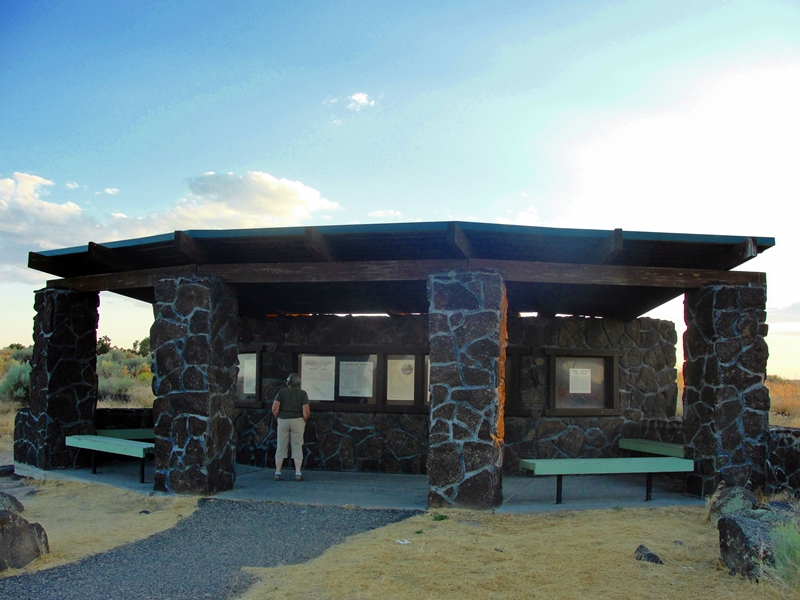
Covered Pavillion at Centennial
Waterfront Park


Perrine Bridge Over Snake River, View From Centennial
Waterfront Park Hiking Trail
This area is close to the better known Shoshone Falls (blog post here).  While in the area, stop at the Perrine Bridge Visitors Center to get fantastic views of the Snake River Canyon and the famous Perrine Bridge (over 1500 feet long and about 500 feet above the Snake River).  This area is just four miles south of I-84 and very much worth the short detour.  The Magic Valley Mall is just across US-93 from the turnoff to the park.

Take a break and enjoy this part of your Idaho Vacation.

Additional Information:
Twin Falls Chamber of Commerce - http://twinfallschamber.com/
South Central Idaho Tourism - http://visitsouthidaho.com/cake/

Tuesday, August 30, 2011

Idaho Vacation: Cave Falls

Cave Falls is not actually in Idaho but in the western edge of Wyoming and also in the southwest corner of Yellowstone National Park.  I list it under Idaho vacations as the only road to the falls is through Idaho. 

Cave Falls in Yellowston National Park on Fall River

Cave Falls at 250 feet wide is the widest of Yellowstone's many waterfalls.  The falls is only about 20 feet high but is a beautiful waterfall on the Fall River.  It is perhaps the easiest waterfall to access and enjoy in the southwestern portion of Yellowstone.  Due to the large number of waterfalls in this region, this corner of Yellowstone is commonly referred to as "Cascade Corner".


Couple Enjoying View of Cave Falls in Yellowstone
National Park on Fall River
 From Ashton or Island Park, the falls is accessable via the Mesa Falls Scenic Byway, ID-47, and the 16 mile long Cave Falls Road (FR 582 after entering the Targee National Forest).  Winter access is by snowmobile.  The western end of the Cave Falls Road (also known as the Marysville Road) is paved but that lasts only a few miles before the road turns to gravel/dirt.  The road was quite washboardy when we traveled it and I suspect it is that way most of the time it is open.  When the road crosses into Wyoming, the road is again paved, a welcome relief.  Shortly after entering Wyoming, you are greeted by an "Entering Yellowstone National Park" sign. 


Fishing Below Unnamed Falls on Fall River in
Yellowstone National Park
 At the parking area for the falls there is another unnamed falls that stretches across the Fall River that is only 8-10 feet high.  From the parking area, it is a walk of 100 yards or so to Cave Falls.  Cave Falls is named after the cave that is at the base of the falls.  A rock slide currently has the trail blocked for the last 50 feet below the falls. 


Fishing Below Cave Falls on Fall River in
Yellowstone National Park
 Fly fishing is very popular in Fall River in this area.  Much of the upper end of Fall River is in a canyon and difficult to access.  Also in this area is the junction of the Bechler River and the trailheads for several other trails that provide access to Yellowstone backcountry.  Fishing inside the park requires a National Park permit.  Fishing outside the park but on the Wyoming side of the border requires a Wyoming state licence. 

The Bechler Ranger Station is just a couple miles from Cave Falls and there are National Forest campgrounds in the area.  This is bear country so travel and recreate accordingly.  It is recommended that you have a bear bell and pepper spray with you at all times.  The campgrounds are supplied with bear proof food storage containers. 

This is a beautiful area with lots of water features, wildlife, and wildflowers.  Because of the remoteness and ruggedness of the area, visitors should take precautions to make sure they have planned for the unexpected.  Use common sense and visits to this area will create memories to last a lifetime. 

Information Sources:
Yellowstone National Park -
Mammoth Backcountry Office
PO Box 168
Yellowstone National Park, WY 82190
Phone: 307-344-2160
http://www.yellowstone-natl-park.com/bechler.htm

Ashton - 
Ashton Chamber of Commerce, PO Box 351, 714 Main St., Ashton, ID 83420
email: info@ashtonidaho.com, Phone 208-652-3355, Fax 208-652-3567
http://www.ashtonidaho.com/,

Caribou/Targhee National Forest, 1405 Hollipark Drive, Idaho Falls, ID  83401, (208) 524-7500.
Ashton/Island Park Ranger District - Hwy 20 in Ashton, website is here


Monday, August 29, 2011

Idaho Vacation: Malad Gorge State Park

Malad Gorge State Park is just one mile off of I-84 but most travelers do not know it is there.  As you travel on your Idaho vacation, make this a stop for impressive canyon views and a beautiful grassy area with picnic tables and rest rooms for a mid-day picnic.  Younger travelers will appreciate the opportunity to stretch their legs and play on the playground equipment before getting back in the car. 


Interpertative Center At Malad Gorge
State Park

Looking Upstream from Overlook
Footbridge at Malad Gorge State Park

Malad Gorge is one of six units that comprise the Thousand Springs State Park.  It is the only unit directly accessible from I-84.  The park is 652 acres and has hiking trails as well as a nice interpretative center near the canyon overlook.  The picnic tables, playground, shade trees and restrooms are separated from the overlook but only a quarter mile or so away.  Camping is not allowed in the park but private campgrounds are located nearby. 


Covered picnic Tables and Grass
Playground at Malad Gorge State Park

To acccess the park, take I-84 exit 147 (Tuttle exit) and proceed north and west one mile to the canyon overlook.  A sturdy footbridge crosses the canyon for excellent views of the river crashing over boulders approximately 175 feet below.  The footbridge is very close to the highway bridge.  From the footbridge, one can look upstream at the staircase rapids.  Immediately under the bridge is Devils Washbowl, a large basin of wild water.  Looking downriver, the gorge deepens to over 250 feet as the river flows toward its confluence with the Snake River just 2 1/2 miles away. 


Malad River Flows Through 250 Ft
Deep Gorge at Malad Gorge State Park

Just a 1/4 mile upstream from the footbridge, is Kelton Crossing.  This was the bridge over the canyon where the Oregon Trail crossed the gorge.  Fortunately the canyon was narrow at this place and only 35-40 feet deep.  This bridge on the Kelton Road carried wagons, freight, passengers, mail, and everything else on the Oregon Train from about 1864 - 1883 when the railroad was built through the area. 

The Malad River is only about 12 miles long and is formed when the Big Wood River and Little Wood Rivers join near Gooding.  The Malad River drains into The Snake River.  From this overlook, there is no trail to the bottom of the gorge. 


Malad River Flows into Devils Washbowl
Photo is Looking Straight Down From Footbridge
 The other units of the Thousand Springs State Park include:
Billingsley Creek -
Vardis Fisher -
Ritter Island -
Earl M Hardy Box Canyon Springs -
Niagara Springs -

Click here for descriptions of all six units. 
Click here for a nice area map showing all six units.


Sunset , View From Malad Gorge State Park
 More information about Idaho State Parks is found on the Idaho State Parks web pages - http://parksandrecreation.idaho.gov/parks or contact them at PO Box 83720, Boise, ID 83720, 888-922-6743.

The fee to enter Idaho State Parks is $5.00/day, season passes are available. 

Saturday, August 20, 2011

Idaho Vacation: Wildlife Canyon Scenic Byway


Wildlife Canyon Scenic Byway Sign
 Scenic byways don't have to be long to be memorable.  Such is the case for the Wildlife Canyon Scenic Byway, a great option for a quick Idaho vacation.  This scenic byway is one of 27 scenic, historic and back country byways scattered throughout Idaho.

This short 33 mile byway follows the South Fork of the Payette River on the Banks-Lowman road.  Access is at either Banks (US-55) or at Lowman (ID-21).  At Banks, the South Fork of the Payette and the North Fork of the Payette come together creating a major waterway often topping 8,000 cubic feet/second during spring runoff. 


Floater With Pontoon Boat in Staircase Rapids
 A popular loop drive from Boise follows US-55 north through Horseshoe Bend along the south half of the Payette River Scenic Byway to Bend. Turn east and travel along the Wildlife Canyon Scenic Byway to Lowman.  Turn south on ID-21 and go through Idaho City along the south half of the Ponderosa Pine Scenic Byway and back to Boise.  Depending on the number of stops, this loop can be made in 1/2 day.  Of course, the loop can be traveled in either direction. 


Rafters Enjoying South Fork Payette
River Whitewater

Banks is a center for whitewater sports.  The greatest flows but tamest waters of the Payette are from Banks south to Horseshoe Bend.   Portions of the North Fork are not run commercially due to the violent nature of the river.  Above Smiths Ferry is popular for day trips.  Perhaps the most sought after river runs are found on the South Fork, the route of our scenic byway. 


Kayak in South Fork Payette
River Whitewater

There are many companies that provide guided trips on the Payette (see contacts below).  Excursions are varied from relatively short and tame all the way to multi-day trips with class IV and V rapids.  Some trips require portage around the largest waterfalls.  Regardless of skill level, a trip is available to fit your time schedule and ability level.  Many of these companies give lessons and sell whitewater equipment. 

There are several turnouts to allow viewing of floaters as they make their way down river.  One of the most popular is the turnout at Staircase Rapids.  Here one can view a relatively long stretch of river as floaters make their way through class IV rapids.  It is exciting even if you are only on the river bank.

Whitewater Action on the South
Fork of Payette River


About seven miles east of Banks, the canyon view opens to wide meadows where the Middle Fork joins the South Fork of the Payette.  One mile north of this junction is the small town of Crouch.  Crouch is mostly a supply town for the few year-round residents and the many summer visitors.  A number of Forest Service campgrounds are located along the Middle Fork and other tributaries.  A special treat is the Starlight Mountain Theater, an outdoor theater, performing professional Broadway shows.  Click here for information about the theater schedule, prices, dinner shows, etc.

Another mile or so east of the Crouch junction is the small town of Garden Valley.  Gas and limited groceries are available here.  Just east of Garden Valley is a Forest Service Ranger Station, another source of information  about the area. 

There are numerous hot springs in this area and continuing east along the highway and river.  Between Garden Valley and Lowman the highway goes past the Danskin wildlife viewing area.  During the winter and  spring large herds of elk use this area for their winter range.  Two pullouts with viewing telescopes have been installed for viewing the numerous elk, deer, chukars, wild turkeys, eagles, osprey, and other wildlife. 


South Fork of Payette River Viewed From Highway Overlook
 Past Danskin, the highway gains elevation to traverse the steep and rugged canyon.  The views for the next several miles are some of the most awe inspiring canyon views in the entire state.  The highway hugs high canyon walls while the river rumbles below.  There are several pullouts that have beautiful panoramic views of the river and waterfalls. 

Continuing east, the roadway drops in elevation and is at river level before reaching Lowman, the eastern terminus of this beautiful scenic byway.  The road is open all year but may be snow covered during winter months.  There is much to see and do along the 33 mile stretch of this beautiful byway.  Hot Springs and Pine Flats campgrounds are just off the highway near the Lowman end.  The highway joins ID-21 at Lowman and one can either return to Boise through Idaho City or continue east and north to Stanley and the Stanley Basin. 

Contact and Information sources (not complete):
Boise National Forest Garden Valley Ranger Station 208-462-3241 or the Boise National Forest,
1249 S. Vinnell Way, Suite 200, Boise, ID 83709, (208) 373-4100, http://fs.usda.gov/boise or email contact at: r4boiseinfo@fs.fed.us
Garden Valley Chamber of Commerce: 208-462-5003, http://www.gvchamber.org/ or email info@gvchamber.org
Bear Valley River Co. - 208-793-2272 or 1-800-235-2327, http://www.bearvalleyrafting.com/ or email bearvalleyraft@gmail.com
Cascade Raft and Kyak - 208-793-2221 or 1-800-292-7238, http://www.cascaderaft.com/
Payette River Company - 208-259-3702(summer) 208-726-8467(winter), http://www.payetterivercompany.com/ or email ginger@payetterivercompany.com
Idaho Whitewater Unlimited - 208-462-1900 or 1-800-800-RAFT, http://www.idahowhitewaterunltd.com/, or email idwhtwtr@idahowhitewaterunltd.com
Riverroots, LLC - 208-850-7637, http://www.riverrootskayak.com/, or email john@riverrootskayak.com

Monday, July 18, 2011

Idaho Vacation: Kelly's Whitewater Park


Entrance to Kelly's WhiteWater Park
   Kelly's Whitewater Park on the Payette River in Cascade is Idaho's only whitewater park.  Make it a stop on your Idaho vacation. 

White water enthusiast? No problem, Kelly's Whitewater Park has 5 water features to give you hours of practice and enjoyment in a pristine environment with water flow regulated by the Cascade Dam located just a mile upriver.

More of a spectator? No problem, Kelly's Whitewater Park has both indoor and outdoor seating with a great overview of the water features.  The grounds are beautifully landscaped and the walking path from the spacious visitors center to upstream features invite you  to walk. 


Part of Landscaped Grounds at Kelly's
Whitewater Park

Beautiful Grounds and Views
at Kelly's Whitewater Park


Part of Exhibit Gallery at Kelly's
Whitewater Park

Kelly's Whitewater Park was just a dream in 2008 when Mayor Dick Carter and Hans Borbonus discussed ways to enhance commerce and opportunities in Cascade.  With 3.4 acres donated by Hans Borbonus and private funding generously provided by Mark and Kristina Pickard, the park became a reality in June of 2010 and continues to make rapid progress.  More enhancements are planned for this work in progress.

Kelly's Whitewater Park is named for Kelly Brennan, late sister of Kristina Pickard 


Plaque Honoring Kelly Brennen, Namesake of Kelly's
Whitewater Park


The large visitors center features an art gallery of mostly local photographs of the area.  Videos of whitewater activities are shown on large video monitors.  Spacious seating allows viewing of the river action in air conditioned comfort.  An information center and store are located in an adjacent building.  The grounds have lots of space to sit on the grass and watch the river action.


Kyaker Practicing in One of the Man-
Made Rapids, Kelly's Whitewater Park

The park is located just 72 miles north of Boise on US-55.  Turn in at mile marker114.44.  This is just south of the railroad tracks on the south edge of Cascade.  There are many other recreational activities available in the Cascade area. 

Almost Buried in Water at Kelly's
Whitewater Park
 
Additional information about the park is found here.  Cascade information is here and here. Information for other area towns include Donnelly and McCall.


Kyaker Riding the Wave at Kelly's Whitewater Park

Practicing a Roll at Kelly's Whitewater Park


Tuesday, June 21, 2011

Idaho Vacation: Shoshone Falls

Spectacular!  In years with an abundance of moisture, Shoshone Falls is a tremendous waterfall.  This is the year to put this on your Idaho travel and vacation agenda.  Shoshone Falls is also known as the Niagara of the West. 

Shoshone Falls in a High Water Year, June 2011

Shoshone Falls is over 900 feet wide and cascades 212 feet, making it higher than Niagara Falls.  Unlike Niagara Falls, Shoshone Falls has the water flow controlled and is often a falls with little water flowing.  Not so this year, the flow is high and the sight is spectacular.  Later this year the flow over the falls will be reduced and the falls will be pretty mundane.  Now is the time to trek to the Twin Falls area to see this sight.


Visitor Overlook at Shoshone Falls
There are actually two waterfalls near Twin Falls that should be visited this year.  Twin Falls, the namesake for the city of Twin Falls, is about four miles upstream from the more well known Shoshone Falls.  In years like 2011, this falls also gives a pretty spectacular show. 

There are other falls along the Snake River in this general area but most are harder to access and don't provide the spectacular show of Twin Falls and Shoshone Falls. 

Water in the Snake River is harnessed for both irrigation and electrical power generation.  There is a power plant operated by Idaho Power on the north side of Shoshone Falls.  Irrigation water is diverted farther upstream.  During dry years and later in the summer, the flow over the falls is reduced to just a small fraction of the natural river slow. 


Upper Portion of Shoshone Falls, June 2011
At both Twin Falls and Shoshone Falls there are parks and picnic facilities.  The area near Shoshone Falls is the better developed and has very nice shaded grassy areas for picnics.  There is also a gift store at the site.  The area is owned and operated by the city of Twin Falls.  Just a quarter mile up the road from the Shoshone Falls parking area is Dirkes Lake and more picnic areas.  These areas are very popular with locals and are worth a visit. 


Picnic Area in Park at Shoshone Falls
If traveling on I-84, take the Twin Falls exit and go about four miles south to cross the Snake River canyon on Perrine Bridge.  Stop on either the north side or south side to view this sheer walled canyon.  There is a visitor center on the south side.  Follow Blue Lakes Boulevard south a little over a mile to Falls Avenue East, turn left and go east three miles to 3300 E road, turn left and head north to the canyon.  Stay on this road to the Falls.  The canyon road is paved and is fairly steep and narrow in a few spots but is negotiable with any vehicle type.  There are large parking areas near the falls.  Click this link for a map of the area.  From May to October, there is a $3.00 fee for access and parking at the falls or to use the picnic areas.

Another great park in this area to visit is the Twin Falls County Centennial Waterfront Park.  This park is located just a mile from the south end of Perrine Bridge.  View the blogpost here.
Shoshone Falls is worthy of an Idaho vacation any time but at high water, it is a must see.  To check water flow rates, call the city of Twin Falls at 208-735-4357 for information.  Click here for additional information about Twin Falls and the surrounding area.