This blog is just getting started. Come back often for updates. Send me a note about places you think should be included, I'll do my best to get it done, PM me @ idahotraveler01@gmail.com.

Thanks for taking time to be here.

Showing posts with label Idaho City. Show all posts

Monday, September 26, 2011

Idaho Vacation: Ponderosa Pine Scenic Byway, Part 2 Idaho City to Lowman

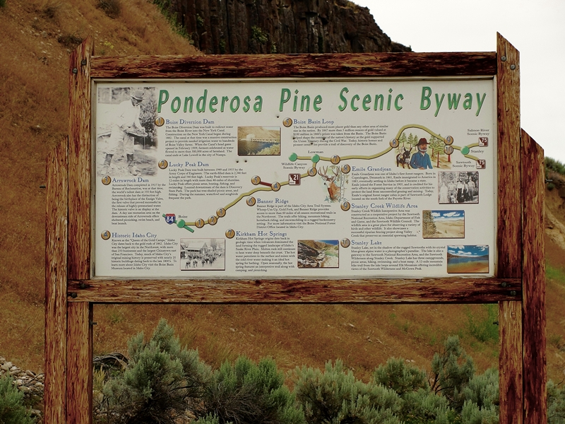
The Ponderosa Pine Scenic Byway is one of the most diversified and beautiful byways in Idaho and in my opinion, the entire country.  Part 1 of the description of this byway is here and covers the first thirty or so miles from Boise to Idaho City.  Part 2 covers from Idaho City to Lowman and Part 3 covers the byway from Lowman to Stanley and is here.  Any way you travel this byway, it is a great Idaho vacation.


Display Inside the Boise Basin Historical Museum
Idaho City
  For information and photos on Idaho City, see my entry here. 

Wood Carving Outside Idaho
City Visitor Center
We leave Idaho City heading north and east, passing several recreational areas.  Mores Creek is quite small here but the road follows the creek side more closely as we proceed up the canyon a few miles from town.  We pass the Rabbit Creek Road which gives access to the North Fork Boise River.  There are many homes along the roadway the first few miles from town.

Old Miners Cabin at Boise Basin
Museum, Idaho City

We gain elevation more quickly as the canyon narrows more and soon come to a series of three National Forest Campgrounds within a couple mile stretch.  A few more miles and switchbacks slow out speed as we tack on elevation on our way to the top of Mores Creek Summit.  Stop at the top and enjoy the view back over the valley you just came through.  It is a nice view. 


View From Highway on Road
to Mores Creek Summit
 About two miles past the summit is Whoop-Um-Up Recreation area.  This is a popular winter sports parking area and trailhead for snowmobile trails and cross country skiing.  There is also a campground with facilities for horses at the area.  This is a National Forest fee area. 

Another half mile is the Edna Creek Campground.  The road by the campground gives access to a wide array of roads leading to the North Fork Boise River, the backcountry Graham area and eventually to Atlanta, an early mining town (see my entry for Atlanta here). 


Convoluted Tree Near Highway
at Banner Summit


Highway Between Banner Summit and Lowman
  Travel another 4-5 miles and arrive at Banner Ridge.  The road here starts a descent that continues all the way to Lowman.  There are several pullout areas and Scenic Overlooks where one can stop and view the amazing countryside.  At one of these pullouts there is an interpretative sign that details the great 1989 Lowman fire. 

The remnants of this huge 47,000 acre fire are visible for miles along the roadway.  Trees were replanted on over 30,000 acres and this plus natural revegation has the area again green.  Fire evidence will be evident for many more years.  The fire burned much of Lowman with some parts that will likely never be rebuilt. 

Lowman is also the junction with the highway that traverses the Wildlife Canyon Scenic Byway (see my entry for this scenic byway here.  Traveling Ponderosa Pine Scenic Byway, the Wildlife Canyon Scenic Byway to Banks then back towards Boise makes a very nice day trip. 

There are several campgrounds within a few miles of Lowman in West, North and East directions.  There is also a Forest Service Ranger Station just outside of Lowman.  Lowman is immediately adjacent to the Middle Fork Payette River. 

If continuing from Lowman on north towards Stanley on the Ponderosa Pine Scenic Byway, go to my blog entry that has Part 3 of this byway here.

Additional Information Sources:
Guide to Idaho's Scenic Byways - http://www.idahobyways.gov/, Idaho Division of Tourism Development,
700 West State Street, P.O. Box 83720, Boise, ID 83720-0093,  Phone: (208) 334-2470
Boise National Forest1249 S. Vinnell Way, Suite 200, Boise, ID 83709, (208) 373-4100,   http://fs.usda.gov/boise
Idaho City Chamber of Commerce - 208-392-4159,  http://www.idahocitychamber.com/

Wednesday, September 21, 2011

Idaho Vacation: Ponderosa Pine Scenic Byway, Part 3 Lowman to Stanley


Ponderosa Pine Scenic Byway near
Diversion Dam
 The Ponderosa Pine Scenic Byway is one of the most scenic and diversified byways imaginable.  It has urban elements at one end, large reservoirs, mining towns, mountain passes, beautiful timber and mountain ranges, rivers,  peaceful valleys and the majestic Sawtooth mountains at the other end.  There are many ways to fit this byway into an Idaho vacation. 

The byway blog is being split into three parts - Part 1 Boise to Idaho City is here, Part 2 covers Idaho City to Lowman, and Part 3 covers Lowman to Stanley.  Be sure to read all three parts to get information on the entire byway. 

Remnants of Lowman Fire


Kirkham Hot Spring Along the Middle Fork
Payette River

Highway ID-21 from Lowman follows the Middle Fork Payette River.  The most popular whitewater rafting/kayaking activities are downriver from here.  We pass miles of fire burned landscape and begin to appreciate the powerful forces at work in shaping and molding the forest world around us.  Nature is wonderful at revegatating the burned landscape.  We pass several campgrounds, some with hot springs and soaking pools.  Check with Boise National Forest for specific campground information.  A few commercial outlets are available to provide gas and nourishment along this area. 


Historic Sign for Emile Grandjean,
Early Forest Ranger
 Before long we arrive at the turnoff for Grandjean, an area named for Emile Grandjean, an early Forest Ranger and environmentalist.  A road leads past summer homes to Sawtooth Lodge and on to Grandjean campground.  Trailheads from here access the western side of the Sawtooth National Recreational Area and the Sawtooth Wilderness Area.


View of Sawtooth Wilderness Area from Grandjean Overlook
 Back on ID-21, don't miss the scenic overlook a few miles east of the Grandjean Road junction.  This is really the first unobstructed view of the majestic Sawtooth Mountain Range. 

Our highway now turns mostly north and rapidly gains elevation as we head towards the top of Banner Summit.  We have left the river behind and now gain serious elevation as the mountains rise sharply on both sides of the highway.  During winter months, this stretch is very prone to avalanches and the highway is frequently closed.  Winter travel should always include a check with the highway department before heading on this stretch of road.  The area is beautiful but give it plenty of respect. 


Fishing Dock at Martin Lake
 From the top of Banner Summit the road is now downhill all the way to Stanley.  We are starting the last major leg of this Idaho scenic byway.  Just a mile past the summit, a dirt road leads left to the popular fishing and camping areas of Bull Trout Lake and the nearby Martin Lake.  These areas have nice camping facilities and access to the lakes which are stocked with rainbow trout.  Martin Lake even has a dock protruding into the lake for handicap fishing.

A couple miles farther along our road is the junction of FR 579, an access to the popular Dagger Falls and Boundry Creek, the major putin for floating the Middle Fork Salmon River.  Also accessible from this road is the Bear Valley and Johnson Creek drainages.  This is also a popular access to Deadwood River and Reservoir.  One can also cut through forest to Landmark, Warm Lake and on to US-55 at Cascade.  Have access to good maps before venturing this route. 


Stanley Lake With McGowen
Peak in Background
 Our road reaches its most northern point as it rounds Cape Horn before beginning a mostly gentle downgrade to the southeast and Stanley.  We pass more picnic areas, campgrounds and wildlife viewing areas as we enter the Sawtooth National Recreational Area.  Valley Creek is to the north of the highway and the rugged Sawtooth Mountains to the south. 

This trip would not be complete without a stop at Stanley Lake, a few miles before arriving in Stanley.  This beautiful blue water lake is backed by McGowen Peak.  Several campgrounds are near the lake shore.  Trails lead into the backcountry. 


View of Sawtooth Mountains West of Stanley, Late June
 The majestic Sawtooth peaks gradually come into better view as we near Stanley.  This has to be the very heart of the most beautiful part of the state in my opinion.  Stanley is the end point for the Ponderosa Pine Scenic Byway. 


Sawtooth Mountains West of Stanley
Late June
 Our byway today has taken us from the Boise River over a major pass to the Middle Fork Payette River then over another major pass to the Salmon River

Be prepared - one cannot travel by road from Stanley without traveling on a scenic byway.  One of the other two roads from Stanley leads to the south through Sun Valley back towards Twin Falls on the Sawtooth Scenic Byway and the other goes down the Salmon River towards Challis, Salmon and the Montana border on the Salmon River Scenic Byway. 
 
Additional Information Sources:
Guide to Idaho's Scenic Byways - http://www.idahobyways.gov/, Idaho Division of Tourism Development,
700 West State Street, P.O. Box 83720, Boise, ID 83720-0093
, Phone: (208) 334-2470
Boise National Forest -    
1249 S. Vinnell Way, Suite 200, Boise, ID 83709
, (208) 373-4100,
rr4boiseinfo@fs.fed.us,  http://fs.usda.gov/boise
Sawtooth National Forest - 2647 Kimberly Road East, Twin Falls, ID 83301, (208)737-3200, http://fs.usda.gov/sawtooth
Sawtooth National Recreational Area - Information is through the Sawtooth National Forest, SNRA Headquarters phone is (208)727-5000, the latest Recreation Report is here.
Stanley, Idaho - Chamber of Commerce, PO 8, Stanley, ID 83278,(208)774-3411, http://www.stanleycc.org/, email information@stanleycc.org

Tuesday, September 20, 2011

Idaho Vacation: Ponderosa Pine Scenic Byway, Part 1 Boise to Idaho City

The Ponderosa Pine Scenic Byway is one of the most scenic and diversified byways imaginable.  It has urban elements at one end, large reservoirs, mining towns, mountain passes, beautiful timber and mountain ranges, rivers,  peaceful valleys and the majestic Sawtooth mountains at the other end.  There are many ways to fit this byway into an Idaho vacation. 

Because of the many things to describe on this byway the post is given in three parts - Part 1 Boise to Idaho City, Part 2 Idaho City to Lowman, and Part 3 Lowman to Stanley. 
The 2-lane paved byway is anchored by Boise on one end and Stanley on the other end.  We will start this trip at the Boise end of this 131 mile wonderful trip.  In addition to the beauty and adventure of the byway, there are many side trips that can be taken from this route. 

Ponderosa Pine Scenic Byway near Diversion Dam

The byway begins near the junction of I-84 and I-21, just southeast of Boise.  The first side trip comes only a mile or so after getting started.  The Oregon Trail Reserve, a 66 acre site is just 500 feet off of our route.  The address for the reserve is 4500 E Lake Forest Dr, Boise.  The reserve features a scenic view of the Boise Front and the historic Kelton Ramp, a path forged by overland travelers heading down the rim to the Boise River.  More information on the reserve is here.


Diversion Dam Historic Sign
 Another mile or so we find our trip along side of the Boise River.  Diversion Dam was originally built to divert water for irrigation.  Shorty after its completion it was fitted with a power plant to supply electrical power for the construction of Arrowrock Dam a few miles upstream.  A history of Diversion Dam is here.

Diversion Dam With Power Plant
on Far Right Side, Boise River 

A couple more miles brings one to Discovery Park, one of three units of Lucky Peak State Park.  This popular roadside park has reservable shelters, picnic areas, fishing access with bike and walking trails.  Sandy Point located about 1/2 mile farther up the road and at the base of Lucky Peak Dam, offers  a great sandy beach and clear cool waters.  It is very popular during warmer weather.  The third unit of Lucky Peak State Park is Spring Shores, about seven more miles along Lucky Peak Reservoir and has a large marina in addition to watercraft rentals and a convenience store.  Admission is charged for these state park units. 

"Rooster Tail" Spillway from Lucky Peak Dam, Boise River

The road leaves the reservoir after the Sandy Point and dam area and loops over a modest hill to the junction of I-21 and FR 268.  FR268 leads to Spring Shores, on to Arrowrock Dam and Reservoir, the Boise National Forest and eventually to Atlanta, an early Idaho mining town.  My entry on Atlanta and the trip getting there is found here.

We stay on I-21 for this trip.  This road is also signed as FR 237.  The roadway follows an arm of Lucky Peak reservoir then enters a canyon with Mores Creek for a roadside companion.  Homes dot the mountain side landscape and the scenery  changes from dry desert to forested slopes.  Deer are numerous along the highway, especially in winter, and special caution is encouraged to avoid collisions. 


Historic Sign at Grimes Creek Junction on ID-21

Watch for the Grimes Creek about 12 miles past the FR237 junction.  The road up Grimes Creek offers fishing, lots of boondocking (no formal camp ground facilities) camping opportunities and access to backcountry ghost towns Placerville, New Centerville, and Pioneerville, among others. The area is a popular snow mobile and tubing area in winter  This area was an extremely important mining district in the latter 1800's.  The mining history is readily visible.  This is also a popular hunting area.

Continuing on I-21 we soon arrive at Idaho City, a historically important and well preserved mining town.  One could spend an entire day here exploring the visitors center, old cemetaries, historical buildings, and the Boise Basin Historical Museum.  See my entry about Idaho City here.

Wood Carving
Outside of Idaho
City Visitor Center

Wood Carving
Outside of Idaho
City Visitor Center

Additional Information Sources:
Guide to Idaho's Scenic Byways - http://www.idahobyways.gov/, Idaho Division of Tourism Development, 700 West State Street, P.O. Box 83720, Boise, ID 83720-0093, Phone: (208) 334-2470
Boise City - http://www.cityofboise.org/, 150 N Capitol Blvd, Boise, ID 83702, 1-800-377-3529
Oregon Trail in Idaho - http://history.idaho.gov/, 2205 Old Penitentiary Rd, Boise, ID 83712, 208-334-2682
Lucky Peak State Park - http://parksandrecreation.idaho.gov/parks/luckypeak.aspx, Location: 8 miles SE of Boise, 74 Arrowrock Rd, Boise, ID 83716, (208) 334-2432
Idaho City Chamber of Commerce - 208-392-4159,    http://www.idahocitychamber.com/,
Boise National Forest -    1249 S. Vinnell Way, Suite 200, Boise, ID 83709, (208) 373-4100,
rmailto:rr4boiseinfo@fs.fed.us, http://fs.usda.gov/boise, (Idaho City Ranger District 208-392-6681)

Saturday, August 20, 2011

Idaho Vacation: Idaho City

Gold!  That was the cry as gold was discovered in the Boise Basin in 1862.  By 1864 some 20,000 miners had flooded to the Idaho City area making this the largest city in the Northwest.  More gold was mined from the area mountains than from all of Alaska.  Visit this historic town and relive the feeling of the 1860's on your Idaho vacation.   

Idaho City Visitors Center

 Idaho City is located less than 40 miles from Boise making this an easy drive and a nice day trip.  The road from Boise to Idaho City follows ID-21, which is also the southern 38 miles of the Ponderosa Pine Scenic Byway.  The Byway continues past Idaho City to Lowman and on to Stanley in the beautiful Stanley Basin and the Salmon River.


Idaho City Ice Cream Shop
 Stop at the attractive Idaho City Visitors Center for helpful information and brochures to be sure you don't miss the many historical sites.  Traverse the wooden sidewalks, enjoy old time shops, and top it off with a delicious ice cream cone from the ice cream shop. 


Idaho City Main Street

Caption on Idaho Territorial
 Penitentiary Idaho City
 Idaho City buildings to visit have many firsts - the 1863 Idaho World building housed Idaho's oldest newspaper.  The Idaho Territorial Penitentiary, a handhewn log prison, housed  the killer of Idaho City's first marshall.  The Boise Basin Mercantile, built in 1865, was Idaho's first general store.  The 1867 St Joseph's Catholic Church replaced an 1863 structure that was Idaho's first Catholic church for whites.


Idaho City Building
 Stop at the Boise Basin Historical Museum to view old photographs, mining tools, and many other artifacts and memorabilia.  On the west end of town is Pioneer Cemetery.  It is reported that of the first 200 graves dug, only 28 were occupied by people who died of natural causes. 


US Flag With 45 Stars
Idaho City Museum
 Today Idaho City is a mix of old and new.  Modern convenience stores, eating establishments, and lodging are available while exploring the old.  motels and RV parks are available.  Idaho City refused to die as have many mining towns even after devastating wildfires destroyed most of the town on two separate occasions. 


Water Cannon Used in Placer Mining
Idaho City Mines

Miners Cabin Idaho City Museum

Idaho City is surrounded by history and mountains, and today boasts about 300 permanent residents.  It is close to hunting and fishing and boasts a newly reopened sledding hill as well as a hot spring and pool 1 1/2 miles southwest of town.  Forest Service campgrounds are located a few miles southwest of town and more northeast of town along ID-21.  Idaho City should be your Idaho vacation destination.  Many events are scheduled during the year as it doesn't take much of an excuse for Idaho City to throw a party. 

Contact Information:
Idaho City Chamber of Commerce - 208-392-4159,  http://www.idahocitychamber.com/,
Boise National Forest -    1249 S. Vinnell Way, Suite 200, Boise, ID 83709, (208) 373-4100,
r4boiseinfo@fs.fed.us, http://fs.usda.gov/boise, (Idaho City Ranger District 208-392-6681)
Warm Springs Resort - 208-392-4437,

Idaho Vacation: Wildlife Canyon Scenic Byway


Wildlife Canyon Scenic Byway Sign
 Scenic byways don't have to be long to be memorable.  Such is the case for the Wildlife Canyon Scenic Byway, a great option for a quick Idaho vacation.  This scenic byway is one of 27 scenic, historic and back country byways scattered throughout Idaho.

This short 33 mile byway follows the South Fork of the Payette River on the Banks-Lowman road.  Access is at either Banks (US-55) or at Lowman (ID-21).  At Banks, the South Fork of the Payette and the North Fork of the Payette come together creating a major waterway often topping 8,000 cubic feet/second during spring runoff. 


Floater With Pontoon Boat in Staircase Rapids
 A popular loop drive from Boise follows US-55 north through Horseshoe Bend along the south half of the Payette River Scenic Byway to Bend. Turn east and travel along the Wildlife Canyon Scenic Byway to Lowman.  Turn south on ID-21 and go through Idaho City along the south half of the Ponderosa Pine Scenic Byway and back to Boise.  Depending on the number of stops, this loop can be made in 1/2 day.  Of course, the loop can be traveled in either direction. 


Rafters Enjoying South Fork Payette
River Whitewater

Banks is a center for whitewater sports.  The greatest flows but tamest waters of the Payette are from Banks south to Horseshoe Bend.   Portions of the North Fork are not run commercially due to the violent nature of the river.  Above Smiths Ferry is popular for day trips.  Perhaps the most sought after river runs are found on the South Fork, the route of our scenic byway. 


Kayak in South Fork Payette
River Whitewater

There are many companies that provide guided trips on the Payette (see contacts below).  Excursions are varied from relatively short and tame all the way to multi-day trips with class IV and V rapids.  Some trips require portage around the largest waterfalls.  Regardless of skill level, a trip is available to fit your time schedule and ability level.  Many of these companies give lessons and sell whitewater equipment. 

There are several turnouts to allow viewing of floaters as they make their way down river.  One of the most popular is the turnout at Staircase Rapids.  Here one can view a relatively long stretch of river as floaters make their way through class IV rapids.  It is exciting even if you are only on the river bank.

Whitewater Action on the South
Fork of Payette River


About seven miles east of Banks, the canyon view opens to wide meadows where the Middle Fork joins the South Fork of the Payette.  One mile north of this junction is the small town of Crouch.  Crouch is mostly a supply town for the few year-round residents and the many summer visitors.  A number of Forest Service campgrounds are located along the Middle Fork and other tributaries.  A special treat is the Starlight Mountain Theater, an outdoor theater, performing professional Broadway shows.  Click here for information about the theater schedule, prices, dinner shows, etc.

Another mile or so east of the Crouch junction is the small town of Garden Valley.  Gas and limited groceries are available here.  Just east of Garden Valley is a Forest Service Ranger Station, another source of information  about the area. 

There are numerous hot springs in this area and continuing east along the highway and river.  Between Garden Valley and Lowman the highway goes past the Danskin wildlife viewing area.  During the winter and  spring large herds of elk use this area for their winter range.  Two pullouts with viewing telescopes have been installed for viewing the numerous elk, deer, chukars, wild turkeys, eagles, osprey, and other wildlife. 


South Fork of Payette River Viewed From Highway Overlook
 Past Danskin, the highway gains elevation to traverse the steep and rugged canyon.  The views for the next several miles are some of the most awe inspiring canyon views in the entire state.  The highway hugs high canyon walls while the river rumbles below.  There are several pullouts that have beautiful panoramic views of the river and waterfalls. 

Continuing east, the roadway drops in elevation and is at river level before reaching Lowman, the eastern terminus of this beautiful scenic byway.  The road is open all year but may be snow covered during winter months.  There is much to see and do along the 33 mile stretch of this beautiful byway.  Hot Springs and Pine Flats campgrounds are just off the highway near the Lowman end.  The highway joins ID-21 at Lowman and one can either return to Boise through Idaho City or continue east and north to Stanley and the Stanley Basin. 

Contact and Information sources (not complete):
Boise National Forest Garden Valley Ranger Station 208-462-3241 or the Boise National Forest,
1249 S. Vinnell Way, Suite 200, Boise, ID 83709, (208) 373-4100, http://fs.usda.gov/boise or email contact at: r4boiseinfo@fs.fed.us
Garden Valley Chamber of Commerce: 208-462-5003, http://www.gvchamber.org/ or email info@gvchamber.org
Bear Valley River Co. - 208-793-2272 or 1-800-235-2327, http://www.bearvalleyrafting.com/ or email bearvalleyraft@gmail.com
Cascade Raft and Kyak - 208-793-2221 or 1-800-292-7238, http://www.cascaderaft.com/
Payette River Company - 208-259-3702(summer) 208-726-8467(winter), http://www.payetterivercompany.com/ or email ginger@payetterivercompany.com
Idaho Whitewater Unlimited - 208-462-1900 or 1-800-800-RAFT, http://www.idahowhitewaterunltd.com/, or email idwhtwtr@idahowhitewaterunltd.com
Riverroots, LLC - 208-850-7637, http://www.riverrootskayak.com/, or email john@riverrootskayak.com

Saturday, January 15, 2011

Great Idaho Vacations - Play in the Snow


Playing in the snow is a natural for a winter Idaho vacation.  With most of the state covered by mountain ranges and snow on the ground for months in many areas, snow activities are easy to find.  Idaho boasts a number of premier ski areas, perhaps topped by legendary Sun Valley.  Thousands of miles of snowmobile and cross-country ski trails are scattered throughout the state.  Thousands of other areas exist for more informal areas to play in the snow.

Areas for tubing, sledding, and other methods of getting from hill tops to hill bottoms are found in countless locations in or near every community and in mountain and public land areas. 

Our latest excursion was to an unnamed area on Grimes Creek to tube and sled.  To reach this area we headed up Hwy 21 towards Idaho City.  At the Grimes Creek junction, we turned left to follow Grimes Creek about four miles to a nice open hill.  In areas like this, one makes their own sliding runs depending on skill of the riders. 

Our assortment of sliding instruments consisted of a tobagon, a snow tube, and a boogy board.  All worked well on the approximately 20 inch deep snow.  As the pictures show, how far or fast one slides is not as important as just being there. 

Don't be overly concerned about having to have "just right" clothing especially for younger kids.  A visit to  a local  thrift store finished outfitting our grandkids in very satisfactory, low cost, snow outfits. 

Our Grimes Creek destination was less than 45 minutes from Boise.  Our total trip was made in an aftrnoon and gave us all the snow time we wanted for the day.  We passed several other areas closer to Boise that were being used by other families having a great day.  Add this to your Idaho things to do list, you will be happy you  did.