Spring, summer, and fall it has trees, shrubs, and flowers. In the winter Idaho Botanical Garden has about 250,000 lights for your enjoyment. Make this an Idaho vacation from Thanksgiving through the first week of January.
The Idaho Botanical Garden is open throughout the year but is transformed into a glow of holiday lights from Thanksgiving day to January 8, 2012. Visit the garden from 6-9pm every evening for the dazzling sparkling lights. In addition to lights, visitors are provided complimentary hot chocolate, hot apple cider, and cookies in the Folly.
For further enjoyment, don't miss the G scale model train display in the English Garden. Santa is present and available for photos and wish lists on weekends and from December 19-23. A special treat is to interact with Prancer, an actual live reindeer, on December weekends and on December 19, 22, and 23 ( Prancer's availability cannot be guaranteed on all hours during these days).
Community and school choirs perform most hours Winter Garden Lights aGlow is open, especially on weekends. Various food vendors are also available on weekends. A complete schedule of activities, vendors, and entertainment groups is here.
The Idaho Botanical Garden is a private non-profit corporation. Land for the garden is leased from the State of Idaho but the garden receives no state funding. The first board of directors was organized in 1984. Fourteen separate theme and display gardens make up the Idaho Botanical Garden.
The garden is located adjacent to the Old Idaho Penitentiary and is part of the Idaho Old Penitentiary District. Hours, directions, and entrance fees are given here. Click here to see the other museums and sites in this historical district.
Additional Information:
Idaho Botanical Garden - http://idahobotanicalgarden.org/index.cfm?fuseaction=feature.display&feature_id=37
Winter Garden Lights aGlow - http://idahobotanicalgarden.org/index.cfm?fuseaction=feature.display&feature_id=33&CFID=1089623&CFTOKEN=69121070
City of Boise - http://www.cityofboise.org/
Boise Convention and Visitors Bureau - http://www.boise.org/
Friday, December 9, 2011
Idaho Vacation: Lionel Hampton International Jazz Festival
Love jazz? Head for Moscow, Idaho in February! The Lionel Hampton International Jazz Festival, held on the University of Idaho campus since 1967, would make a great Idaho vacation.
Four full days of everything jazz from February 22-25, 2012 will bring thousands of participants and spectators to Moscow. The festival is renowned for the variety and breath of music and dance in this four day period.
In addition to evening concerts with international artists, daytime programs focus on workshops for grade school, middle school, high school and college musicians and their conductors. Internationally renown artists as well as Lionel Hampton School of Music faculty and other invited clinicians present the daytime workshops. There is truly something for everyone.
According to the festival website, the festival is "designed to entertain, inspire, educate, and inform". Since its beginning in 1967 with 12 student groups and one guest artist, the event has grown each year. Lionel Hampton joined the festival in 1984. After experiencing the enthusiasm of the students, Hamp pledged his support of the festival. The festival adopted his name in 1987.
What a way to spend an Idaho winter vacation. Make it part of your plans.
Additional information:
Lionel Hampton International Jazz Festival - http://www.uidaho.edu/jazzfest/festival/aboutfestival
City of Moscow, Idaho - http://www.moscowchamber.com/
University of Idaho - http://www.uidaho.edu/
Lionel Hampton School of Music - http://www.uidaho.edu/class/music/
Tuesday, November 15, 2011
Idaho Vacation: McCall Winter Carnival Update for 2012
Late January and early February is an exciting time to be in McCall. This is a great Idaho vacation. The 47th annual McCall Winter Carnival is 10 days of fun activities that will make you forget how cold the winter actually is. Mark your calendars for January 27th to February 5th, 2012.
Check this site for a schedule of events. There is something for every age and interest. I wrote about the 2011 event here. This blog entry is an update for 2012 with photos of some of the snow sculptures from the 2011 carnival.
Here are a few of the scheduled events:
Local as well as Idaho State Championship Snow Sculpting
Beer Gardens
Several Music Venues
Kids Carnival
Torchlight Parade
Fireworks over Payette Lake
Mardi Gras Parade
Chocolate and Spirits Tasting
Beard, Hairy, & Sexy Leg Competition
Monte Carlo Casino Night
Family Bingo
Come and enjoy the fun, celebrate winter. There are many other activities to enjoy while in the McCall area. Little Ski Hill, Brundage and Tamarack ski areas are just a few miles from town. Snow tubing is available at the Activity Barn (described here). Cross country skiing and snowmobiling is available any direction from town. Ponderosa State Park (blog here) is serene and beautiful in the winter.
McCall is approximately 108 miles north of Boise on ID-55 which is also the Payette River Scenic Byway. From Lewiston, the mileage is 163 miles.
Additional Information:
McCall Chamber of Commerce - http://mccallchamber.org/
 |
| Snow Sculpture 2011 McCall Winter Carnival |
Check this site for a schedule of events. There is something for every age and interest. I wrote about the 2011 event here. This blog entry is an update for 2012 with photos of some of the snow sculptures from the 2011 carnival.
Most major events are scheduled for weekends but those days will also have the largest crowds. For less congestion, consider a visit during the week. There are still lots of activities.
 |
| Snow Sculpture 2011 McCall Winter Carnival |
Local as well as Idaho State Championship Snow Sculpting
Beer Gardens
Several Music Venues
Kids Carnival
Torchlight Parade
Fireworks over Payette Lake
Mardi Gras Parade
Chocolate and Spirits Tasting
Beard, Hairy, & Sexy Leg Competition
Monte Carlo Casino Night
Family Bingo
 |
| Snow Sculpture 2011 McCall Winter Carnival |
 |
| Snow Sculpture 2011 McCall Winter Carnival |
 |
| Snow Sculpture 2011 McCall Winter Carnival |
Additional Information:
 |
| Public Watching Snow Sculptors at Work 2011 Winter Carnival |
Thursday, November 10, 2011
Idaho Vacation: Payette River Scenic Byway
The Payette River Scenic Byway is 112 miles of non-stop scenic views; most will simply take your breath away. This byway is a great Idaho
The southern end of this byway is at the junction of ID-55 and ID 44 just west of Boise
 |
| Payette River Scenic Byway Information Sign |
The southern portion of this byway skirts around the city of Eagle and heads north on the Horseshoe Bend road. After topping the pass between the metro Boise Boise National Forest Payette River Bend
In addition to a few places to grab a bite to eat, there are two other reasons to make a stop in Horseshoe Bend. The Thunder Mountain Line features scenic train rides along the Payette River
One other note about Horseshoe Bend, it is best to not exceed the 25 MPH speed limit through town. This author found that it is “strictly” enforced.
 |
| Rafters Enjoying a Float Down The Payette River |
For the next 35 or so miles, the road follows the Payette River Idaho
Numerous outfitters and guides provide expert advice and equipment for river excursions. Trips can be tailored to any age and/or experience level. See contact information below. The North Fork and South Fork Payette River North Fork is mostly a continuous series of Class 5 rapids and is not suitable for rafters and kayakers who are not experts.
 |
| Winter on The North Fork Payette River |
Several Forest Service campgrounds are located near the highway in this stretch and there are a number of turnouts to allow slower drivers to safely pullover and let those in a hurry to pass. A number of turnouts allow for viewing rafters and kayakers on the river. There is also a nice beach area a couple miles south of Banks. There is also access to many secondary roads that lead away from the river and to many other camping and other outdoor recreational opportunities. The road is open all seasons but will likely be snow covered and/or icy during winter months. It is best to not be in a big hurry on this stretch of highway.
 |
| Kayaking at Kelly's Whitewater Park near Cascade |
The highway east from Banks follows the South Fork Payette River Boise Stanley Sawtooth Mountains
 |
| Rainbow Bridge Over North Fork Payette River |
 |
| ID-55 Holiday Traffic Heading South Along the Payette River |
ID-55 is one of two main highways from the Boise Idaho
A few miles north of Smith’s Ferry the road leaves the river and soon opens to the Round Valley Round Valley Long Valley Long Valley
 |
| Cattle Grazing in a Meadow in Long Valley |
 |
| Fall Colors in Aspen Near Cascade |
Cascade is the gateway to Cascade Reservoir, a twenty mile long impoundment on the Payette River
 |
| Fall Colors With Cascade Reservoir in Background |
FR 22 goes east of Cascade towards Warm Lake Salmon River and Johnson Creek. Access to many other lakes and streams are found in the area. Tamarack Resort is located near the North West
Continuing north on ID-55 we soon arrive in Donnelly, the main access point to Tamarack Resort. Donnelly has a few stores, restaurants and gas stations but not much else. We continue our trip towards McCall.
 |
| Pastoral Scene With Tamarack Trees Changing Color Near Smith's Ferry |
The resort town of McCall Payette Lake Ponderosa State park
From McCall we head in a more westerly direction towards the community of New Meadows. ID-55 and the Payette River Scenic Byway end in New Meadows where the highway intersects with US-95. Turn right and head towards Riggins and Grangeville and points north or stay left and head towards Council and back to the western Treasure Valley
The route makes a great day-trip loop or just go up and back on ID-55. The scenery will look different depending on which way you travel. This makes a wonderful Idaho
Additional Information:
Boise National Forest - http://fs.usda.gov/boise/
Horseshoe Bend - http://www.horseshoebendidaho.com/
Idaho Scenic Byways - http://www.idahobyways.org/ or http://www.visitidaho.org/scenic-byways/
Idaho Outfitters and Guides Ass'n (White Water Trips) - http://www.ioga.org/
Idaho Historical Highway Marker Guide - http://itd.idaho.gov/hmg/
Cascade Chamber of Commerce - http://www.cascadechamber.com/
Lake Cascade State Park - http://parksandrecreation.idaho.gov/parks/lakecascade.aspx
Donnelly Chamber of Commerce - http://www.donnellychamber.org/
Tamarack Resort - http://www.tamarackidaho.com/
McCall Chamber of Commerce - http://mccallchamber.org/
Brundage Mountain Ski Area and Resort - http://www.brundage.com/
New Meadows Area Information - http://meadowsvalley.com/
Saturday, October 22, 2011
Idaho Vacation: EBR-1, The World's First Nuclear Reactor
Experimental Breeder Reactor-1 generated electrical power onDecember 20, 1951 . This marked the first time in the world usable electrical power was produced from nuclear fuel. The facility, located in the desert 18 miles southeast of Arco and 50 miles west of Idaho Falls
The entire EBR-1 building was turned into anAtomic Museum
The museum is open from daily from Memorial Day through Labor Day weekend. Tours are free and can be either self-guided or guided. Photographs are not only allowed in this nuclear reactor but encouraged.
The unimpressive exterior of EBR-1 belies what is inside. Each of 15 marked exhibits have extensive explanations of not only what one can see but educational information on the processes of converting atomic fuel into usable electricity. This is truly an educational experience. The self-guided brochures add to the information presentation.
A new exhibit opened in 2011 showcasing EBR-2, the successor to EBR-1. EBR-2 operated from 1964 until 1994. This exhibit has replicas of the control room and main floor of the reactor. EBR-2 was larger and more advanced than EBR-1 and supplied most of the electrical power needed by the National Engineering Laboratory while it was active.
Outside, near the parking lot, are two aircraft nuclear engine prototypes. They were never commercially developed.
 |
| Highway Historic Marker at Rest Area on Highway 20-26 near EBR-1 Atomic Museum |
EBR-1 made history about 60 years ago by producing the world's first usable electrical power using atomic energy. A tour of this National Historic Landmark makes a great Idaho
Experimental Breeder Reactor-1 generated electrical power on
 |
| Arco, Idaho City Hall With Signage Showing It To Be First City in World To Be Lit by Atomic Power |
The entire EBR-1 building was turned into an
The museum is open from daily from Memorial Day through Labor Day weekend. Tours are free and can be either self-guided or guided. Photographs are not only allowed in this nuclear reactor but encouraged.
 |
| EBR-1 National Historic Landmark, World's First Nuclear Power Plant |
A new exhibit opened in 2011 showcasing EBR-2, the successor to EBR-1. EBR-2 operated from 1964 until 1994. This exhibit has replicas of the control room and main floor of the reactor. EBR-2 was larger and more advanced than EBR-1 and supplied most of the electrical power needed by the National Engineering Laboratory while it was active.
Outside, near the parking lot, are two aircraft nuclear engine prototypes. They were never commercially developed.
 |
| Sign at Highway Turnoff at EBR-1 Atomic Museum |
The emphasis throughout this one-of-a-kind Atomic Museum
Take an hour to visit this museum while traveling through the Idaho Idaho Falls Moon National Monument Idaho
Additional Information:
EBR-1 - http://www.inl.gov/ebr/
Arco Chamber of Commerce - http://www.arcochamber.com/communityInfo.asp
Monday, September 26, 2011
Idaho Vacation: Ponderosa Pine Scenic Byway, Part 2 Idaho City to Lowman
The Ponderosa Pine Scenic Byway is one of the most diversified and beautiful byways in Idaho and in my opinion, the entire country. Part 1 of the description of this byway is here and covers the first thirty or so miles from Boise to Idaho City. Part 2 covers from Idaho City to Lowman and Part 3 covers the byway from Lowman to Stanley and is here. Any way you travel this byway, it is a great Idaho vacation.
For information and photos on Idaho City, see my entry here.
We leave Idaho City heading north and east, passing several recreational areas. Mores Creek is quite small here but the road follows the creek side more closely as we proceed up the canyon a few miles from town. We pass the Rabbit Creek Road which gives access to the North Fork Boise River. There are many homes along the roadway the first few miles from town.
About two miles past the summit is Whoop-Um-Up Recreation area. This is a popular winter sports parking area and trailhead for snowmobile trails and cross country skiing. There is also a campground with facilities for horses at the area. This is a National Forest fee area.
Another half mile is the Edna Creek Campground. The road by the campground gives access to a wide array of roads leading to the North Fork Boise River, the backcountry Graham area and eventually to Atlanta, an early mining town (see my entry for Atlanta here).
Travel another 4-5 miles and arrive at Banner Ridge. The road here starts a descent that continues all the way to Lowman. There are several pullout areas and Scenic Overlooks where one can stop and view the amazing countryside. At one of these pullouts there is an interpretative sign that details the great 1989 Lowman fire.
The remnants of this huge 47,000 acre fire are visible for miles along the roadway. Trees were replanted on over 30,000 acres and this plus natural revegation has the area again green. Fire evidence will be evident for many more years. The fire burned much of Lowman with some parts that will likely never be rebuilt.
Lowman is also the junction with the highway that traverses the Wildlife Canyon Scenic Byway (see my entry for this scenic byway here. Traveling Ponderosa Pine Scenic Byway, the Wildlife Canyon Scenic Byway to Banks then back towards Boise makes a very nice day trip.
There are several campgrounds within a few miles of Lowman in West, North and East directions. There is also a Forest Service Ranger Station just outside of Lowman. Lowman is immediately adjacent to the Middle Fork Payette River.
If continuing from Lowman on north towards Stanley on the Ponderosa Pine Scenic Byway, go to my blog entry that has Part 3 of this byway here.
Additional Information Sources:
Guide toIdaho
700 West State Street, P.O. Box 83720,Boise , ID 83720-0093, Phone: (208) 334-2470
Boise National Forest Boise , ID 83709, (208) 373-4100, http://fs.usda.gov/boise
Idaho City Chamber of Commerce - 208-392-4159, http://www.idahocitychamber.com/
 |
| Display Inside the Boise Basin Historical Museum Idaho City |
 |
| Wood Carving Outside Idaho City Visitor Center |
 |
| Old Miners Cabin at Boise Basin Museum, Idaho City |
We gain elevation more quickly as the canyon narrows more and soon come to a series of three National Forest Campgrounds within a couple mile stretch. A few more miles and switchbacks slow out speed as we tack on elevation on our way to the top of Mores Creek Summit. Stop at the top and enjoy the view back over the valley you just came through. It is a nice view.
 |
| View From Highway on Road to Mores Creek Summit |
Another half mile is the Edna Creek Campground. The road by the campground gives access to a wide array of roads leading to the North Fork Boise River, the backcountry Graham area and eventually to Atlanta, an early mining town (see my entry for Atlanta here).
 |
| Convoluted Tree Near Highway at Banner Summit |
 |
| Highway Between Banner Summit and Lowman |
The remnants of this huge 47,000 acre fire are visible for miles along the roadway. Trees were replanted on over 30,000 acres and this plus natural revegation has the area again green. Fire evidence will be evident for many more years. The fire burned much of Lowman with some parts that will likely never be rebuilt.
Lowman is also the junction with the highway that traverses the Wildlife Canyon Scenic Byway (see my entry for this scenic byway here. Traveling Ponderosa Pine Scenic Byway, the Wildlife Canyon Scenic Byway to Banks then back towards Boise makes a very nice day trip.
There are several campgrounds within a few miles of Lowman in West, North and East directions. There is also a Forest Service Ranger Station just outside of Lowman. Lowman is immediately adjacent to the Middle Fork Payette River.
If continuing from Lowman on north towards Stanley on the Ponderosa Pine Scenic Byway, go to my blog entry that has Part 3 of this byway here.
Additional Information Sources:
Guide to
700 West State Street, P.O. Box 83720,
Idaho City Chamber of Commerce - 208-392-4159, http://www.idahocitychamber.com/
Wednesday, September 21, 2011
Idaho Vacation: Ponderosa Pine Scenic Byway, Part 3 Lowman to Stanley
The Ponderosa Pine Scenic Byway is one of the most scenic and diversified byways imaginable. It has urban elements at one end, large reservoirs, mining towns, mountain passes, beautiful timber and mountain ranges, rivers, peaceful valleys and the majestic Sawtooth mountains at the other end. There are many ways to fit this byway into an Idaho
The byway blog is being split into three parts - Part 1Boise Idaho City is here , Part 2 covers Idaho Stanley
Before long we arrive at the turnoff for Grandjean, an area named for Emile Grandjean, an early Forest Ranger and environmentalist. A road leads past summer homes to Sawtooth Lodge and on to Grandjean campground. Trailheads from here access the western side of the Sawtooth National Recreational Area and the Sawtooth Wilderness Area.
Back on ID-21, don't miss the scenic overlook a few miles east of the Grandjean Road junction. This is really the first unobstructed view of the majestic Sawtooth Mountain Range.
Our highway now turns mostly north and rapidly gains elevation as we head towards the top of Banner Summit. We have left the river behind and now gain serious elevation as the mountains rise sharply on both sides of the highway. During winter months, this stretch is very prone to avalanches and the highway is frequently closed. Winter travel should always include a check with the highway department before heading on this stretch of road. The area is beautiful but give it plenty of respect.
From the top of Banner Summit the road is now downhill all the way to Stanley Idaho Bull Trout Lake Martin Lake Martin Lake
A couple miles farther along our road is the junction of FR 579, an access to the popularDagger Falls Bear Valley Deadwood River Warm Lake
Our road reaches its most northern point as it rounds Cape Horn before beginning a mostly gentle downgrade to the southeast and Stanley. We pass more picnic areas, campgrounds and wildlife viewing areas as we enter the Sawtooth National Recreational Area. Valley Creek is to the north of the highway and the rugged Sawtooth Mountains
This trip would not be complete without a stop atStanley Lake Stanley McGowen Peak
The majestic Sawtooth peaks gradually come into better view as we near Stanley Stanley
Our byway today has taken us from the Boise River Middle Fork Payette River Salmon River .
Be prepared - one cannot travel by road fromStanley Stanley Sun Valley back towards Twin Falls Salmon River towards Challis, Salmon and the Montana
Additional Information Sources:
Guide toIdaho
700 West State Street, P.O. Box 83720 , Boise , ID 83720-0093 , Phone: (208) 334-2470
Boise National Forest
1249 S. Vinnell Way, Suite 200 , Boise , ID 83709 , (208) 373-4100,
rr4boiseinfo@fs.fed.us, http://fs.usda.gov/boise
Sawtooth National Forest - 2647 Kimberly Road East, Twin Falls, ID 83301, (208)737-3200, http://fs.usda.gov/sawtooth
Sawtooth National Recreational Area - Information is through the Sawtooth National Forest, SNRA Headquarters phone is (208)727-5000, the latest Recreation Report is here.
Stanley, Idaho - Chamber of Commerce, PO 8, Stanley, ID 83278,(208)774-3411, http://www.stanleycc.org/, email information@stanleycc.org
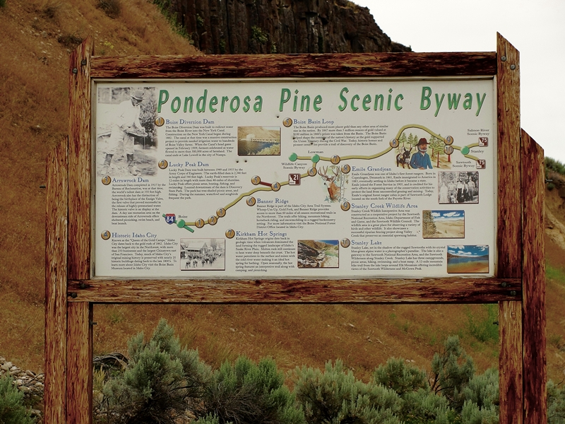 |
| Ponderosa Pine Scenic Byway near Diversion Dam |
The byway blog is being split into three parts - Part 1
 |
| Remnants of Lowman Fire |
 |
| Kirkham Hot Spring Along the Middle Fork Payette River |
Highway ID-21 from Lowman follows the Middle Fork Payette River hot springs Boise National Forest
 |
| Historic Sign for Emile Grandjean, Early Forest Ranger |
 |
| View of Sawtooth Wilderness Area from Grandjean Overlook |
Our highway now turns mostly north and rapidly gains elevation as we head towards the top of Banner Summit. We have left the river behind and now gain serious elevation as the mountains rise sharply on both sides of the highway. During winter months, this stretch is very prone to avalanches and the highway is frequently closed. Winter travel should always include a check with the highway department before heading on this stretch of road. The area is beautiful but give it plenty of respect.
 |
| Fishing Dock at Martin Lake |
A couple miles farther along our road is the junction of FR 579, an access to the popular
 |
| Stanley Lake With McGowen Peak in Background |
This trip would not be complete without a stop at
 |
| View of Sawtooth Mountains West of Stanley, Late June |
 |
| Sawtooth Mountains West of Stanley Late June |
Be prepared - one cannot travel by road from
Additional Information Sources:
Guide to
rr4boiseinfo@fs.fed.us, http://fs.usda.gov/boise
Sawtooth National Forest - 2647 Kimberly Road East, Twin Falls, ID 83301, (208)737-3200, http://fs.usda.gov/sawtooth
Sawtooth National Recreational Area - Information is through the Sawtooth National Forest, SNRA Headquarters phone is (208)727-5000, the latest Recreation Report is here.
Stanley, Idaho - Chamber of Commerce, PO 8, Stanley, ID 83278,(208)774-3411, http://www.stanleycc.org/, email information@stanleycc.org
Tuesday, September 20, 2011
Idaho Vacation: Ponderosa Pine Scenic Byway, Part 1 Boise to Idaho City
The Ponderosa Pine Scenic Byway is one of the most scenic and diversified byways imaginable. It has urban elements at one end, large reservoirs, mining towns, mountain passes, beautiful timber and mountain ranges, rivers, peaceful valleys and the majestic Sawtooth mountains at the other end. There are many ways to fit this byway into an Idaho vacation.
The byway begins near the junction of I-84 and I-21, just southeast of Boise. The first side trip comes only a mile or so after getting started. The Oregon Trail Reserve, a 66 acre site is just 500 feet off of our route. The address for the reserve is 4500 E Lake Forest Dr, Boise. The reserve features a scenic view of the Boise Front and the historic Kelton Ramp, a path forged by overland travelers heading down the rim to the Boise River. More information on the reserve is here.
Another mile or so we find our trip along side of the Boise River. Diversion Dam was originally built to divert water for irrigation. Shorty after its completion it was fitted with a power plant to supply electrical power for the construction of Arrowrock Dam a few miles upstream. A history of Diversion Dam is here.
The road leaves the reservoir after the Sandy Point and dam area and loops over a modest hill to the junction of I-21 and FR 268. FR268 leads to Spring Shores, on to Arrowrock Dam and Reservoir, the Boise National Forest and eventually to Atlanta, an early Idaho mining town. My entry on Atlanta and the trip getting there is found here.
We stay on I-21 for this trip. This road is also signed as FR 237. The roadway follows an arm of Lucky Peak reservoir then enters a canyon with Mores Creek for a roadside companion. Homes dot the mountain side landscape and the scenery changes from dry desert to forested slopes. Deer are numerous along the highway, especially in winter, and special caution is encouraged to avoid collisions.
Continuing on I-21 we soon arrive at Idaho City, a historically important and well preserved mining town. One could spend an entire day here exploring the visitors center, old cemetaries, historical buildings, and the Boise Basin Historical Museum. See my entry about Idaho City here.
Boise City - http://www.cityofboise.org/, 150 N Capitol Blvd, Boise, ID 83702, 1-800-377-3529
Oregon Trail in Idaho - http://history.idaho.gov/, 2205 Old Penitentiary Rd, Boise, ID 83712, 208-334-2682
Lucky Peak State Park - http://parksandrecreation.idaho.gov/parks/luckypeak.aspx, Location: 8 miles SE of Boise, 74 Arrowrock Rd, Boise, ID 83716, (208) 334-2432
Idaho City Chamber of Commerce - 208-392-4159, http://www.idahocitychamber.com/,
Boise National Forest - 1249 S. Vinnell Way, Suite 200, Boise, ID 83709, (208) 373-4100,
rmailto:rr4boiseinfo@fs.fed.us, http://fs.usda.gov/boise, (Idaho City Ranger District 208-392-6681)
Because of the many things to describe on this byway the post is given in three parts - Part 1 Boise to Idaho City, Part 2 Idaho City to Lowman, and Part 3 Lowman to Stanley.
The 2-lane paved byway is anchored by Boise on one end and Stanley on the other end. We will start this trip at the Boise end of this 131 mile wonderful trip. In addition to the beauty and adventure of the byway, there are many side trips that can be taken from this route.
 |
| Ponderosa Pine Scenic Byway near Diversion Dam |
The byway begins near the junction of I-84 and I-21, just southeast of Boise. The first side trip comes only a mile or so after getting started. The Oregon Trail Reserve, a 66 acre site is just 500 feet off of our route. The address for the reserve is 4500 E Lake Forest Dr, Boise. The reserve features a scenic view of the Boise Front and the historic Kelton Ramp, a path forged by overland travelers heading down the rim to the Boise River. More information on the reserve is here.
 |
| Diversion Dam Historic Sign |
 |
| Diversion Dam With Power Plant on Far Right Side, Boise River |
A couple more miles brings one to Discovery Park, one of three units of Lucky Peak State Park. This popular roadside park has reservable shelters, picnic areas, fishing access with bike and walking trails. Sandy Point located about 1/2 mile farther up the road and at the base of Lucky Peak Dam, offers a great sandy beach and clear cool waters. It is very popular during warmer weather. The third unit of Lucky Peak State Park is Spring Shores, about seven more miles along Lucky Peak Reservoir and has a large marina in addition to watercraft rentals and a convenience store. Admission is charged for these state park units.
 |
| "Rooster Tail" Spillway from Lucky Peak Dam, Boise River |
The road leaves the reservoir after the Sandy Point and dam area and loops over a modest hill to the junction of I-21 and FR 268. FR268 leads to Spring Shores, on to Arrowrock Dam and Reservoir, the Boise National Forest and eventually to Atlanta, an early Idaho mining town. My entry on Atlanta and the trip getting there is found here.
We stay on I-21 for this trip. This road is also signed as FR 237. The roadway follows an arm of Lucky Peak reservoir then enters a canyon with Mores Creek for a roadside companion. Homes dot the mountain side landscape and the scenery changes from dry desert to forested slopes. Deer are numerous along the highway, especially in winter, and special caution is encouraged to avoid collisions.
 |
| Historic Sign at Grimes Creek Junction on ID-21 |
Watch for the Grimes Creek about 12 miles past the FR237 junction. The road up Grimes Creek offers fishing, lots of boondocking (no formal camp ground facilities) camping opportunities and access to backcountry ghost towns Placerville, New Centerville, and Pioneerville, among others. The area is a popular snow mobile and tubing area in winter This area was an extremely important mining district in the latter 1800's. The mining history is readily visible. This is also a popular hunting area.
Continuing on I-21 we soon arrive at Idaho City, a historically important and well preserved mining town. One could spend an entire day here exploring the visitors center, old cemetaries, historical buildings, and the Boise Basin Historical Museum. See my entry about Idaho City here.
 |
| Wood Carving Outside of Idaho City Visitor Center |
 |
| Wood Carving Outside of Idaho City Visitor Center |
Additional Information Sources:
Guide to Idaho's Scenic Byways - http://www.idahobyways.gov/, Idaho Division of Tourism Development, 700 West State Street, P.O. Box 83720, Boise, ID 83720-0093, Phone: (208) 334-2470
Oregon Trail in Idaho - http://history.idaho.gov/, 2205 Old Penitentiary Rd, Boise, ID 83712, 208-334-2682
Lucky Peak State Park - http://parksandrecreation.idaho.gov/parks/luckypeak.aspx, Location: 8 miles SE of Boise, 74 Arrowrock Rd, Boise, ID 83716, (208) 334-2432
Idaho City Chamber of Commerce - 208-392-4159, http://www.idahocitychamber.com/,
Boise National Forest - 1249 S. Vinnell Way, Suite 200, Boise, ID 83709, (208) 373-4100,
rmailto:rr4boiseinfo@fs.fed.us, http://fs.usda.gov/boise, (Idaho City Ranger District 208-392-6681)
Tuesday, August 30, 2011
Idaho Vacation: Cave Falls
Cave Falls is not actually in Idaho but in the western edge of Wyoming and also in the southwest corner of Yellowstone National Park. I list it under Idaho vacations as the only road to the falls is through Idaho.
Cave Falls at 250 feet wide is the widest of Yellowstone's many waterfalls. The falls is only about 20 feet high but is a beautiful waterfall on the Fall River. It is perhaps the easiest waterfall to access and enjoy in the southwestern portion of Yellowstone. Due to the large number of waterfalls in this region, this corner of Yellowstone is commonly referred to as "Cascade Corner".
From Ashton or Island Park, the falls is accessable via the Mesa Falls Scenic Byway, ID-47, and the 16 mile long Cave Falls Road (FR 582 after entering the Targee National Forest). Winter access is by snowmobile. The western end of the Cave Falls Road (also known as the Marysville Road) is paved but that lasts only a few miles before the road turns to gravel/dirt. The road was quite washboardy when we traveled it and I suspect it is that way most of the time it is open. When the road crosses into Wyoming, the road is again paved, a welcome relief. Shortly after entering Wyoming, you are greeted by an "Entering Yellowstone National Park" sign.
At the parking area for the falls there is another unnamed falls that stretches across the Fall River that is only 8-10 feet high. From the parking area, it is a walk of 100 yards or so to Cave Falls. Cave Falls is named after the cave that is at the base of the falls. A rock slide currently has the trail blocked for the last 50 feet below the falls.
Fly fishing is very popular in Fall River in this area. Much of the upper end of Fall River is in a canyon and difficult to access. Also in this area is the junction of the Bechler River and the trailheads for several other trails that provide access to Yellowstone backcountry. Fishing inside the park requires a National Park permit. Fishing outside the park but on the Wyoming side of the border requires a Wyoming state licence.
The Bechler Ranger Station is just a couple miles from Cave Falls and there are National Forest campgrounds in the area. This is bear country so travel and recreate accordingly. It is recommended that you have a bear bell and pepper spray with you at all times. The campgrounds are supplied with bear proof food storage containers.
This is a beautiful area with lots of water features, wildlife, and wildflowers. Because of the remoteness and ruggedness of the area, visitors should take precautions to make sure they have planned for the unexpected. Use common sense and visits to this area will create memories to last a lifetime.
Information Sources:
Yellowstone National Park -
Mammoth Backcountry Office
PO Box 168
Yellowstone National Park, WY 82190
Phone: 307-344-2160
http://www.yellowstone-natl-park.com/bechler.htm
Ashton -
Ashton Chamber of Commerce, PO Box 351, 714 Main St., Ashton, ID 83420
email: info@ashtonidaho.com, Phone 208-652-3355, Fax 208-652-3567
http://www.ashtonidaho.com/,
Caribou/Targhee National Forest, 1405 Hollipark Drive, Idaho Falls, ID 83401, (208) 524-7500.
Ashton/Island Park Ranger District - Hwy 20 in Ashton, website is here
 |
| Cave Falls in Yellowston National Park on Fall River |
Cave Falls at 250 feet wide is the widest of Yellowstone's many waterfalls. The falls is only about 20 feet high but is a beautiful waterfall on the Fall River. It is perhaps the easiest waterfall to access and enjoy in the southwestern portion of Yellowstone. Due to the large number of waterfalls in this region, this corner of Yellowstone is commonly referred to as "Cascade Corner".
 |
Couple Enjoying View of Cave Falls in Yellowstone National Park on Fall River |
 |
| Fishing Below Unnamed Falls on Fall River in Yellowstone National Park |
 |
| Fishing Below Cave Falls on Fall River in Yellowstone National Park |
The Bechler Ranger Station is just a couple miles from Cave Falls and there are National Forest campgrounds in the area. This is bear country so travel and recreate accordingly. It is recommended that you have a bear bell and pepper spray with you at all times. The campgrounds are supplied with bear proof food storage containers.
This is a beautiful area with lots of water features, wildlife, and wildflowers. Because of the remoteness and ruggedness of the area, visitors should take precautions to make sure they have planned for the unexpected. Use common sense and visits to this area will create memories to last a lifetime.
Information Sources:
Yellowstone National Park -
Mammoth Backcountry Office
PO Box 168
Yellowstone National Park, WY 82190
Phone: 307-344-2160
http://www.yellowstone-natl-park.com/bechler.htm
Ashton -
Ashton Chamber of Commerce, PO Box 351, 714 Main St., Ashton, ID 83420
email: info@ashtonidaho.com, Phone 208-652-3355, Fax 208-652-3567
http://www.ashtonidaho.com/,
Caribou/Targhee National Forest, 1405 Hollipark Drive, Idaho Falls, ID 83401, (208) 524-7500.
Ashton/Island Park Ranger District - Hwy 20 in Ashton, website is here
Subscribe to:
Posts (Atom)