This blog is just getting started. Come back often for updates. Send me a note about places you think should be included, I'll do my best to get it done, PM me @ idahotraveler01@gmail.com.

Thanks for taking time to be here.

Showing posts with label Fish. Show all posts

Monday, September 26, 2011

Idaho Vacation: Ponderosa Pine Scenic Byway, Part 2 Idaho City to Lowman

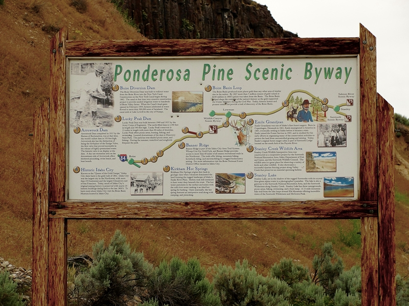
The Ponderosa Pine Scenic Byway is one of the most diversified and beautiful byways in Idaho and in my opinion, the entire country.  Part 1 of the description of this byway is here and covers the first thirty or so miles from Boise to Idaho City.  Part 2 covers from Idaho City to Lowman and Part 3 covers the byway from Lowman to Stanley and is here.  Any way you travel this byway, it is a great Idaho vacation.


Display Inside the Boise Basin Historical Museum
Idaho City
  For information and photos on Idaho City, see my entry here. 

Wood Carving Outside Idaho
City Visitor Center
We leave Idaho City heading north and east, passing several recreational areas.  Mores Creek is quite small here but the road follows the creek side more closely as we proceed up the canyon a few miles from town.  We pass the Rabbit Creek Road which gives access to the North Fork Boise River.  There are many homes along the roadway the first few miles from town.

Old Miners Cabin at Boise Basin
Museum, Idaho City

We gain elevation more quickly as the canyon narrows more and soon come to a series of three National Forest Campgrounds within a couple mile stretch.  A few more miles and switchbacks slow out speed as we tack on elevation on our way to the top of Mores Creek Summit.  Stop at the top and enjoy the view back over the valley you just came through.  It is a nice view. 


View From Highway on Road
to Mores Creek Summit
 About two miles past the summit is Whoop-Um-Up Recreation area.  This is a popular winter sports parking area and trailhead for snowmobile trails and cross country skiing.  There is also a campground with facilities for horses at the area.  This is a National Forest fee area. 

Another half mile is the Edna Creek Campground.  The road by the campground gives access to a wide array of roads leading to the North Fork Boise River, the backcountry Graham area and eventually to Atlanta, an early mining town (see my entry for Atlanta here). 


Convoluted Tree Near Highway
at Banner Summit


Highway Between Banner Summit and Lowman
  Travel another 4-5 miles and arrive at Banner Ridge.  The road here starts a descent that continues all the way to Lowman.  There are several pullout areas and Scenic Overlooks where one can stop and view the amazing countryside.  At one of these pullouts there is an interpretative sign that details the great 1989 Lowman fire. 

The remnants of this huge 47,000 acre fire are visible for miles along the roadway.  Trees were replanted on over 30,000 acres and this plus natural revegation has the area again green.  Fire evidence will be evident for many more years.  The fire burned much of Lowman with some parts that will likely never be rebuilt. 

Lowman is also the junction with the highway that traverses the Wildlife Canyon Scenic Byway (see my entry for this scenic byway here.  Traveling Ponderosa Pine Scenic Byway, the Wildlife Canyon Scenic Byway to Banks then back towards Boise makes a very nice day trip. 

There are several campgrounds within a few miles of Lowman in West, North and East directions.  There is also a Forest Service Ranger Station just outside of Lowman.  Lowman is immediately adjacent to the Middle Fork Payette River. 

If continuing from Lowman on north towards Stanley on the Ponderosa Pine Scenic Byway, go to my blog entry that has Part 3 of this byway here.

Additional Information Sources:
Guide to Idaho's Scenic Byways - http://www.idahobyways.gov/, Idaho Division of Tourism Development,
700 West State Street, P.O. Box 83720, Boise, ID 83720-0093,  Phone: (208) 334-2470
Boise National Forest1249 S. Vinnell Way, Suite 200, Boise, ID 83709, (208) 373-4100,   http://fs.usda.gov/boise
Idaho City Chamber of Commerce - 208-392-4159,  http://www.idahocitychamber.com/

Wednesday, September 21, 2011

Idaho Vacation: Ponderosa Pine Scenic Byway, Part 3 Lowman to Stanley


Ponderosa Pine Scenic Byway near
Diversion Dam
 The Ponderosa Pine Scenic Byway is one of the most scenic and diversified byways imaginable.  It has urban elements at one end, large reservoirs, mining towns, mountain passes, beautiful timber and mountain ranges, rivers,  peaceful valleys and the majestic Sawtooth mountains at the other end.  There are many ways to fit this byway into an Idaho vacation. 

The byway blog is being split into three parts - Part 1 Boise to Idaho City is here, Part 2 covers Idaho City to Lowman, and Part 3 covers Lowman to Stanley.  Be sure to read all three parts to get information on the entire byway. 

Remnants of Lowman Fire


Kirkham Hot Spring Along the Middle Fork
Payette River

Highway ID-21 from Lowman follows the Middle Fork Payette River.  The most popular whitewater rafting/kayaking activities are downriver from here.  We pass miles of fire burned landscape and begin to appreciate the powerful forces at work in shaping and molding the forest world around us.  Nature is wonderful at revegatating the burned landscape.  We pass several campgrounds, some with hot springs and soaking pools.  Check with Boise National Forest for specific campground information.  A few commercial outlets are available to provide gas and nourishment along this area. 


Historic Sign for Emile Grandjean,
Early Forest Ranger
 Before long we arrive at the turnoff for Grandjean, an area named for Emile Grandjean, an early Forest Ranger and environmentalist.  A road leads past summer homes to Sawtooth Lodge and on to Grandjean campground.  Trailheads from here access the western side of the Sawtooth National Recreational Area and the Sawtooth Wilderness Area.


View of Sawtooth Wilderness Area from Grandjean Overlook
 Back on ID-21, don't miss the scenic overlook a few miles east of the Grandjean Road junction.  This is really the first unobstructed view of the majestic Sawtooth Mountain Range. 

Our highway now turns mostly north and rapidly gains elevation as we head towards the top of Banner Summit.  We have left the river behind and now gain serious elevation as the mountains rise sharply on both sides of the highway.  During winter months, this stretch is very prone to avalanches and the highway is frequently closed.  Winter travel should always include a check with the highway department before heading on this stretch of road.  The area is beautiful but give it plenty of respect. 


Fishing Dock at Martin Lake
 From the top of Banner Summit the road is now downhill all the way to Stanley.  We are starting the last major leg of this Idaho scenic byway.  Just a mile past the summit, a dirt road leads left to the popular fishing and camping areas of Bull Trout Lake and the nearby Martin Lake.  These areas have nice camping facilities and access to the lakes which are stocked with rainbow trout.  Martin Lake even has a dock protruding into the lake for handicap fishing.

A couple miles farther along our road is the junction of FR 579, an access to the popular Dagger Falls and Boundry Creek, the major putin for floating the Middle Fork Salmon River.  Also accessible from this road is the Bear Valley and Johnson Creek drainages.  This is also a popular access to Deadwood River and Reservoir.  One can also cut through forest to Landmark, Warm Lake and on to US-55 at Cascade.  Have access to good maps before venturing this route. 


Stanley Lake With McGowen
Peak in Background
 Our road reaches its most northern point as it rounds Cape Horn before beginning a mostly gentle downgrade to the southeast and Stanley.  We pass more picnic areas, campgrounds and wildlife viewing areas as we enter the Sawtooth National Recreational Area.  Valley Creek is to the north of the highway and the rugged Sawtooth Mountains to the south. 

This trip would not be complete without a stop at Stanley Lake, a few miles before arriving in Stanley.  This beautiful blue water lake is backed by McGowen Peak.  Several campgrounds are near the lake shore.  Trails lead into the backcountry. 


View of Sawtooth Mountains West of Stanley, Late June
 The majestic Sawtooth peaks gradually come into better view as we near Stanley.  This has to be the very heart of the most beautiful part of the state in my opinion.  Stanley is the end point for the Ponderosa Pine Scenic Byway. 


Sawtooth Mountains West of Stanley
Late June
 Our byway today has taken us from the Boise River over a major pass to the Middle Fork Payette River then over another major pass to the Salmon River

Be prepared - one cannot travel by road from Stanley without traveling on a scenic byway.  One of the other two roads from Stanley leads to the south through Sun Valley back towards Twin Falls on the Sawtooth Scenic Byway and the other goes down the Salmon River towards Challis, Salmon and the Montana border on the Salmon River Scenic Byway. 
 
Additional Information Sources:
Guide to Idaho's Scenic Byways - http://www.idahobyways.gov/, Idaho Division of Tourism Development,
700 West State Street, P.O. Box 83720, Boise, ID 83720-0093
, Phone: (208) 334-2470
Boise National Forest -    
1249 S. Vinnell Way, Suite 200, Boise, ID 83709
, (208) 373-4100,
rr4boiseinfo@fs.fed.us,  http://fs.usda.gov/boise
Sawtooth National Forest - 2647 Kimberly Road East, Twin Falls, ID 83301, (208)737-3200, http://fs.usda.gov/sawtooth
Sawtooth National Recreational Area - Information is through the Sawtooth National Forest, SNRA Headquarters phone is (208)727-5000, the latest Recreation Report is here.
Stanley, Idaho - Chamber of Commerce, PO 8, Stanley, ID 83278,(208)774-3411, http://www.stanleycc.org/, email information@stanleycc.org

Monday, January 31, 2011

Idaho Vacation: Wilson Springs, An Urban Fishery

Wilson Springs, located in south Nampa, is more than an urban fishery, it is an outdoor playground.  This is a great year-round destination for your Idaho vacation.  Make it a favorite thing to do any season of the year.

First the area - Wilson Springs Nature Area and Fishing Ponds is the full name but locals refer to the area as Wilson Springs. This 55 acre nature area is across the road from the Nampa Fish Hatchery and in Nampa city limits.  A kiosk near the entrance from the main parking lot provides an overview of the area and explains the regulations. 

Second the fishery. Fed by springs, there are four ponds and a central drain open to fishing year round.  Two ponds are stocked with rainbow trout weekly during winter months and less frequently in spring and fall.  Bluegill are also present in these ponds.  One pond is devoted to warm water fish and feature largemouth bass.  The 4th pond is a trophy trout pond with special regulations.  Paved paths and docks extending into the ponds offer accessibility for handicapped individuals.  A number of unpaved paths gives many access points to the ponds.  The fishery is popular especially for older residents and families with younger children as fishing is relatively easy. 


Third the paths and hiking trails.  Paved paths wind through the area providing access to all ponds and a wetlands area.  Unpaved paths follow the edges of ponds to give access to more of the natural area and the ponds.  This area is very popular with local residents for outdoor exercise.  It is rare to be completely alone in the Wilson Springs area.  Having said that - the area does not give a crowded feeling.  There is a lot of area to give everyone their own space. 

Fourth the other wildlife.  Due to the water and lush native vegetation, the area is very popular with a wide variety of birds including raptors, shorebirds, songbirds, upland birds, and waterfowl.  During the winter months, at least 15 species of waterfowl alone can be seen at the area.  Because the ponds are spring fed, they are ice free all winter except for the very coldest weather. 

Access is easy, activities are varied, fun is to be enjoyed.  You will be glad you took time to visit.  Come often. 

Information:
Directions: I-84 Exit #38; S onto Garrity Blvd 0.3 mi; L (E) onto Flamingo Ave 0.1 mi; curve R (S) and Flamingo turns into Happy Valley Rd; go 3.2 mi; R (W) onto Greenhurst 1.9 mi; L (S) on S Powerline Rd 0.7 mi; R (W) into Wilson Ponds parking lot.  It is about 3351 S Powerline Rd. 

 Idaho Fish and Game web site: fishandgame.idaho.gov.  The Southwest Regional IDFG office is located on the north edge of the Wilson springs area at 3101 S Powerline Rd. 

Idaho Vacation: Visit a Fish Hatchery

Idaho has been described as a "Land of Opportunity" for sport fishing. This report focuses on the Idaho Department of Fish and Game operated hatcheries that raise many of the fish for the "catch". With nineteen hatcheries scattered across the state,they make an excellent things to do for your Idaho vacation.

Although operated by IDFG, many of the hatcheries are owned by other entities including Idaho Power Company. Twelve of the hatcheries raise fish that stay in fresh waters all their lives with the remaining hatcheries raising salmon and steelhead that spend part of their lives in the ocean. Licence fees fund the hatcheries that raise fresh water fish and Idaho Power Company and others fund the hatcheries that raise salmon and steelhead as mitigation for the construction of dams on the Columbia and Snake Rivers.

All of the hatcheries welcome visitors. Facilities at each hatchery vary but many have areas for picnics and or camping and some have family or youth fishing waters on site or in the immediate vicinity. Some have viewing ponds where large fish representing several species are present, including Idaho's largest fish, the White Sturgeon. Depending on the land area at the hatchery, some also have hiking trails for bird and other wildlife viewing. Many hatcheries have educational exhibits and welcome larger groups with advance notice. All hatcheries are open year round but have different activities and fish available during various parts of the year.

An excellent web site provides great information for each hatchery. Go to fishandgame.idaho.gov/fish/hatcheries.  This lists the details for each hatchery with driving directions, hours, facilities and all else you need to know.  The main Fish and Game website is fishandgame.idaho.gov.  This site has information about all Fish and Game programs, seasons, regulations, etc. 

Whether or not you enjoy fishing, you are sure to enjoy a visit to an Idaho fish hatchery.  Children will especially appreciate a break from travel to watch the fish.  Enjoy this Idaho vacation.