This blog is just getting started. Come back often for updates. Send me a note about places you think should be included, I'll do my best to get it done, PM me @ idahotraveler01@gmail.com.

Thanks for taking time to be here.

Showing posts with label Historical Markers. Show all posts

Tuesday, January 31, 2012

Idaho Vacation: Nampa Train Depot Museum


Nampa Train Depot Museum,  Nampa, Idaho
While there are many old railroad depots that have been turned into museums, there are few, if any, that rival the beautiful Baroque revival architecture of the Nampa Train Depot Museum.  Make this scenic building and contents a quick Idaho vacation stop. 

Built by the Oregon Short Line Railroad in 1903, the depot was the 2nd in Nampa, replacing the original depot built in 1887.   The building now houses displays of the Canyon County Historical Society and Union Pacific Railroad. 

Old Railroad Sign, Nampa Train
Depot Museum
The museum was saved from demolition in 1972 and dedicated and opened  to the public on July 3, 1976.  Between 1972 and 1976, the building was partially restored and the beautiful woodwork was rebuilt and replaced.  The original woodwork had been removed while the depot served as offices and storage between 1925 and 1972. 

The museum has three main exhibit rooms plus offices for the Canyon County Historical Society and a museum store. 

Model of Dewey Palace Hotel,
Nampa Train Depot Museum
In what was originally the Women's and Children's Waiting Room, a feature exhibit is a replica of the Dewey Palace Hotel, once the largest and most stately in the region.  Another exhibit demonstrates the classy travel clothes that were typical of the period.  There are also several items from Thomas Edison's contributions including a gramophone and various light bulbs.  The "Bronco Billy" western classic starring Clint Eastwood was shot in several SW Idaho locations including Nampa.  Memorabilia and props from the movie are on exhibit.  Other items of interest are also located in this room.

Early Edison Phonograph,
Nampa Train Depot Museum
The original Station Office is now full of railroad items.  Try out the telegraph, or view one of the two working train sets and see if you can find the miniature animals, lookouts, and other fascinating features in the display.  Also on display are a huge collection of locks and keys, old lanterns and other antique office machines. 
Part of Model Train Exhibit,
Nampa Train Depot Museum

In the original Men's Waiting Room are beautiful hand crafted wooden train models made by a Nampa artist.  Also found here in another model train display with lots of detail area surrounding the tracks that depicts an Idaho mountain town. 

Part of Hand Crafted Wooden Train Models,
Nampa Train Depot Museum
Outdoors is a 1942 caboose that is open for inspection.  The museum has a large collection of books and photographs of the area.  Museum staff will help with research efforts if they are given some advance notice. 

The museum hosts many school and youth groups and is open to the public.  Museum hours are
Wednesday - Friday 11:00am to 5:00pm and Saturdays 10:00am  to 2:00pm (May-October) and 11:00am to 2:00pm November-April. 

Lock and Key Display,
Nampa Train Depot Museum
The Museum is located at 1200 Front Street, Nampa.  Access from I-84 is quite easy from either Exit 36 or 38.  You cannot miss the railroad tracks in downtown Nampa.

Need a suggestion for a place to eat?  Click here for details on a great Mexican meal or here for wonderful Chinese food.  Both are located close to the museum. 

Additional Information:

Canyon County Historical Society: http://www.canyoncountyhistory.com/about
City of Nampa: http://ci.nampa.id.us/pages/home.php
Nampa Chamber of Commerce: http://www.nampa.com/

Friday, December 9, 2011

Idaho Vacation: Idaho Botanical Garden, Winter Garden aGlow

Spring, summer, and fall it has trees, shrubs, and flowers.  In the winter Idaho Botanical Garden has about 250,000 lights for your enjoyment.  Make this an Idaho vacation from Thanksgiving through the first week of January. 

The Idaho Botanical Garden is open throughout the year but is transformed into a glow of holiday lights from Thanksgiving day to January 8, 2012.  Visit the garden from 6-9pm every evening for the dazzling sparkling lights.  In addition to  lights, visitors are provided complimentary hot chocolate, hot apple cider, and cookies in the Folly. 

For further enjoyment, don't miss the G scale model train display in the English Garden.  Santa is present and available for photos and wish lists on weekends and from December 19-23.  A special treat is to interact with Prancer, an actual live reindeer, on December weekends and on December 19, 22, and 23 ( Prancer's availability cannot be guaranteed on all hours during these days). 

Community and school choirs perform most hours Winter Garden Lights aGlow is open, especially on weekends.  Various food vendors are also available on weekends.  A complete schedule of activities, vendors, and entertainment groups is here.

 The Idaho Botanical Garden is a private non-profit corporation.  Land for the garden is leased from the State of Idaho but the garden receives no state funding.  The first board of directors was organized in 1984.  Fourteen separate theme and display gardens make up the Idaho Botanical Garden. 

The garden is located adjacent to the Old Idaho Penitentiary and is part of the Idaho Old Penitentiary District.  Hours, directions, and entrance fees are given here.  Click here to see the other museums and sites in this historical district. 


Additional Information:
Idaho Botanical Garden - http://idahobotanicalgarden.org/index.cfm?fuseaction=feature.display&feature_id=37

Winter Garden Lights aGlow - http://idahobotanicalgarden.org/index.cfm?fuseaction=feature.display&feature_id=33&CFID=1089623&CFTOKEN=69121070

City of Boise - http://www.cityofboise.org/

Boise Convention and Visitors Bureau - http://www.boise.org/

Saturday, October 22, 2011

Idaho Vacation: EBR-1, The World's First Nuclear Reactor


Highway Historic Marker at Rest Area on Highway 20-26
near EBR-1 Atomic Museum

EBR-1 made history about 60 years ago by producing the world's first usable electrical power using atomic energy.  A tour of this National Historic Landmark makes a great Idaho vacation. 

Experimental Breeder Reactor-1 generated electrical power on December 20, 1951.  This marked the first time in the world usable electrical power was produced from nuclear fuel.  The facility, located in the desert 18 miles southeast of Arco and 50 miles west of Idaho Falls, is just a mile off of US 20, 26.  In 1955 nuclear power from this reactor lit up the city of Arco, the first city to be lit by atomic power.

Arco, Idaho City Hall With Signage Showing It To Be
 First City in World To Be Lit by Atomic Power

The entire EBR-1 building was turned into an Atomic Museum after the reactor was decommissioned in 1964.  President Lyndon B Johnson dedicated EBR-1 as a National Historic Landmark in 1966. 

The museum is open from daily from Memorial Day through Labor Day weekend.  Tours are free and can be either self-guided or guided.  Photographs are not only allowed in this nuclear reactor but encouraged. 


EBR-1 National Historic Landmark, World's First
Nuclear Power Plant
 The unimpressive exterior of EBR-1 belies what is inside.  Each of 15 marked exhibits have extensive explanations of not only what one can see but educational information on the processes of converting atomic fuel into usable electricity.  This is truly an educational experience.  The self-guided brochures add to the information presentation. 

A new exhibit opened in 2011 showcasing EBR-2, the successor to EBR-1.  EBR-2 operated from 1964 until 1994.  This exhibit has replicas of the control room and main floor of the reactor.  EBR-2 was larger and more advanced than EBR-1 and supplied most of the electrical power needed by the National Engineering Laboratory while it was active. 

Outside, near the parking lot, are two aircraft nuclear engine prototypes.  They were never commercially developed. 

Sign at Highway Turnoff at EBR-1 Atomic Museum

The emphasis throughout this one-of-a-kind Atomic Museum focuses on education and the history of nuclear power.  One can follow the pioneers of nuclear power development through the well signed exhibits as well as their theories about nuclear power.  Signage in the EBR-2 room even takes a look into the future about the possibilities of nuclear power development. 

Take an hour to visit this museum while traveling through the Idaho desert.  Idaho Falls is 50 miles to the east, Blackfoot 40 miles to the southeast, and Arco is 18 miles northwest.  Just another 20 miles west of Arco is the famous Craters of the Moon National Monument.  This is one great Idaho vacation stop. 

Additional Information:


Monday, September 26, 2011

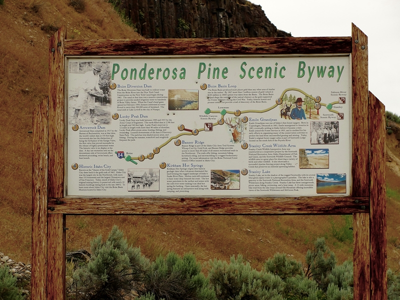
Idaho Vacation: Ponderosa Pine Scenic Byway, Part 2 Idaho City to Lowman

The Ponderosa Pine Scenic Byway is one of the most diversified and beautiful byways in Idaho and in my opinion, the entire country.  Part 1 of the description of this byway is here and covers the first thirty or so miles from Boise to Idaho City.  Part 2 covers from Idaho City to Lowman and Part 3 covers the byway from Lowman to Stanley and is here.  Any way you travel this byway, it is a great Idaho vacation.


Display Inside the Boise Basin Historical Museum
Idaho City
  For information and photos on Idaho City, see my entry here. 

Wood Carving Outside Idaho
City Visitor Center
We leave Idaho City heading north and east, passing several recreational areas.  Mores Creek is quite small here but the road follows the creek side more closely as we proceed up the canyon a few miles from town.  We pass the Rabbit Creek Road which gives access to the North Fork Boise River.  There are many homes along the roadway the first few miles from town.

Old Miners Cabin at Boise Basin
Museum, Idaho City

We gain elevation more quickly as the canyon narrows more and soon come to a series of three National Forest Campgrounds within a couple mile stretch.  A few more miles and switchbacks slow out speed as we tack on elevation on our way to the top of Mores Creek Summit.  Stop at the top and enjoy the view back over the valley you just came through.  It is a nice view. 


View From Highway on Road
to Mores Creek Summit
 About two miles past the summit is Whoop-Um-Up Recreation area.  This is a popular winter sports parking area and trailhead for snowmobile trails and cross country skiing.  There is also a campground with facilities for horses at the area.  This is a National Forest fee area. 

Another half mile is the Edna Creek Campground.  The road by the campground gives access to a wide array of roads leading to the North Fork Boise River, the backcountry Graham area and eventually to Atlanta, an early mining town (see my entry for Atlanta here). 


Convoluted Tree Near Highway
at Banner Summit


Highway Between Banner Summit and Lowman
  Travel another 4-5 miles and arrive at Banner Ridge.  The road here starts a descent that continues all the way to Lowman.  There are several pullout areas and Scenic Overlooks where one can stop and view the amazing countryside.  At one of these pullouts there is an interpretative sign that details the great 1989 Lowman fire. 

The remnants of this huge 47,000 acre fire are visible for miles along the roadway.  Trees were replanted on over 30,000 acres and this plus natural revegation has the area again green.  Fire evidence will be evident for many more years.  The fire burned much of Lowman with some parts that will likely never be rebuilt. 

Lowman is also the junction with the highway that traverses the Wildlife Canyon Scenic Byway (see my entry for this scenic byway here.  Traveling Ponderosa Pine Scenic Byway, the Wildlife Canyon Scenic Byway to Banks then back towards Boise makes a very nice day trip. 

There are several campgrounds within a few miles of Lowman in West, North and East directions.  There is also a Forest Service Ranger Station just outside of Lowman.  Lowman is immediately adjacent to the Middle Fork Payette River. 

If continuing from Lowman on north towards Stanley on the Ponderosa Pine Scenic Byway, go to my blog entry that has Part 3 of this byway here.

Additional Information Sources:
Guide to Idaho's Scenic Byways - http://www.idahobyways.gov/, Idaho Division of Tourism Development,
700 West State Street, P.O. Box 83720, Boise, ID 83720-0093,  Phone: (208) 334-2470
Boise National Forest1249 S. Vinnell Way, Suite 200, Boise, ID 83709, (208) 373-4100,   http://fs.usda.gov/boise
Idaho City Chamber of Commerce - 208-392-4159,  http://www.idahocitychamber.com/

Wednesday, September 21, 2011

Idaho Vacation: Ponderosa Pine Scenic Byway, Part 3 Lowman to Stanley


Ponderosa Pine Scenic Byway near
Diversion Dam
 The Ponderosa Pine Scenic Byway is one of the most scenic and diversified byways imaginable.  It has urban elements at one end, large reservoirs, mining towns, mountain passes, beautiful timber and mountain ranges, rivers,  peaceful valleys and the majestic Sawtooth mountains at the other end.  There are many ways to fit this byway into an Idaho vacation. 

The byway blog is being split into three parts - Part 1 Boise to Idaho City is here, Part 2 covers Idaho City to Lowman, and Part 3 covers Lowman to Stanley.  Be sure to read all three parts to get information on the entire byway. 

Remnants of Lowman Fire


Kirkham Hot Spring Along the Middle Fork
Payette River

Highway ID-21 from Lowman follows the Middle Fork Payette River.  The most popular whitewater rafting/kayaking activities are downriver from here.  We pass miles of fire burned landscape and begin to appreciate the powerful forces at work in shaping and molding the forest world around us.  Nature is wonderful at revegatating the burned landscape.  We pass several campgrounds, some with hot springs and soaking pools.  Check with Boise National Forest for specific campground information.  A few commercial outlets are available to provide gas and nourishment along this area. 


Historic Sign for Emile Grandjean,
Early Forest Ranger
 Before long we arrive at the turnoff for Grandjean, an area named for Emile Grandjean, an early Forest Ranger and environmentalist.  A road leads past summer homes to Sawtooth Lodge and on to Grandjean campground.  Trailheads from here access the western side of the Sawtooth National Recreational Area and the Sawtooth Wilderness Area.


View of Sawtooth Wilderness Area from Grandjean Overlook
 Back on ID-21, don't miss the scenic overlook a few miles east of the Grandjean Road junction.  This is really the first unobstructed view of the majestic Sawtooth Mountain Range. 

Our highway now turns mostly north and rapidly gains elevation as we head towards the top of Banner Summit.  We have left the river behind and now gain serious elevation as the mountains rise sharply on both sides of the highway.  During winter months, this stretch is very prone to avalanches and the highway is frequently closed.  Winter travel should always include a check with the highway department before heading on this stretch of road.  The area is beautiful but give it plenty of respect. 


Fishing Dock at Martin Lake
 From the top of Banner Summit the road is now downhill all the way to Stanley.  We are starting the last major leg of this Idaho scenic byway.  Just a mile past the summit, a dirt road leads left to the popular fishing and camping areas of Bull Trout Lake and the nearby Martin Lake.  These areas have nice camping facilities and access to the lakes which are stocked with rainbow trout.  Martin Lake even has a dock protruding into the lake for handicap fishing.

A couple miles farther along our road is the junction of FR 579, an access to the popular Dagger Falls and Boundry Creek, the major putin for floating the Middle Fork Salmon River.  Also accessible from this road is the Bear Valley and Johnson Creek drainages.  This is also a popular access to Deadwood River and Reservoir.  One can also cut through forest to Landmark, Warm Lake and on to US-55 at Cascade.  Have access to good maps before venturing this route. 


Stanley Lake With McGowen
Peak in Background
 Our road reaches its most northern point as it rounds Cape Horn before beginning a mostly gentle downgrade to the southeast and Stanley.  We pass more picnic areas, campgrounds and wildlife viewing areas as we enter the Sawtooth National Recreational Area.  Valley Creek is to the north of the highway and the rugged Sawtooth Mountains to the south. 

This trip would not be complete without a stop at Stanley Lake, a few miles before arriving in Stanley.  This beautiful blue water lake is backed by McGowen Peak.  Several campgrounds are near the lake shore.  Trails lead into the backcountry. 


View of Sawtooth Mountains West of Stanley, Late June
 The majestic Sawtooth peaks gradually come into better view as we near Stanley.  This has to be the very heart of the most beautiful part of the state in my opinion.  Stanley is the end point for the Ponderosa Pine Scenic Byway. 


Sawtooth Mountains West of Stanley
Late June
 Our byway today has taken us from the Boise River over a major pass to the Middle Fork Payette River then over another major pass to the Salmon River

Be prepared - one cannot travel by road from Stanley without traveling on a scenic byway.  One of the other two roads from Stanley leads to the south through Sun Valley back towards Twin Falls on the Sawtooth Scenic Byway and the other goes down the Salmon River towards Challis, Salmon and the Montana border on the Salmon River Scenic Byway. 
 
Additional Information Sources:
Guide to Idaho's Scenic Byways - http://www.idahobyways.gov/, Idaho Division of Tourism Development,
700 West State Street, P.O. Box 83720, Boise, ID 83720-0093
, Phone: (208) 334-2470
Boise National Forest -    
1249 S. Vinnell Way, Suite 200, Boise, ID 83709
, (208) 373-4100,
rr4boiseinfo@fs.fed.us,  http://fs.usda.gov/boise
Sawtooth National Forest - 2647 Kimberly Road East, Twin Falls, ID 83301, (208)737-3200, http://fs.usda.gov/sawtooth
Sawtooth National Recreational Area - Information is through the Sawtooth National Forest, SNRA Headquarters phone is (208)727-5000, the latest Recreation Report is here.
Stanley, Idaho - Chamber of Commerce, PO 8, Stanley, ID 83278,(208)774-3411, http://www.stanleycc.org/, email information@stanleycc.org

Tuesday, September 20, 2011

Idaho Vacation: Ponderosa Pine Scenic Byway, Part 1 Boise to Idaho City

The Ponderosa Pine Scenic Byway is one of the most scenic and diversified byways imaginable.  It has urban elements at one end, large reservoirs, mining towns, mountain passes, beautiful timber and mountain ranges, rivers,  peaceful valleys and the majestic Sawtooth mountains at the other end.  There are many ways to fit this byway into an Idaho vacation. 

Because of the many things to describe on this byway the post is given in three parts - Part 1 Boise to Idaho City, Part 2 Idaho City to Lowman, and Part 3 Lowman to Stanley. 
The 2-lane paved byway is anchored by Boise on one end and Stanley on the other end.  We will start this trip at the Boise end of this 131 mile wonderful trip.  In addition to the beauty and adventure of the byway, there are many side trips that can be taken from this route. 

Ponderosa Pine Scenic Byway near Diversion Dam

The byway begins near the junction of I-84 and I-21, just southeast of Boise.  The first side trip comes only a mile or so after getting started.  The Oregon Trail Reserve, a 66 acre site is just 500 feet off of our route.  The address for the reserve is 4500 E Lake Forest Dr, Boise.  The reserve features a scenic view of the Boise Front and the historic Kelton Ramp, a path forged by overland travelers heading down the rim to the Boise River.  More information on the reserve is here.


Diversion Dam Historic Sign
 Another mile or so we find our trip along side of the Boise River.  Diversion Dam was originally built to divert water for irrigation.  Shorty after its completion it was fitted with a power plant to supply electrical power for the construction of Arrowrock Dam a few miles upstream.  A history of Diversion Dam is here.

Diversion Dam With Power Plant
on Far Right Side, Boise River 

A couple more miles brings one to Discovery Park, one of three units of Lucky Peak State Park.  This popular roadside park has reservable shelters, picnic areas, fishing access with bike and walking trails.  Sandy Point located about 1/2 mile farther up the road and at the base of Lucky Peak Dam, offers  a great sandy beach and clear cool waters.  It is very popular during warmer weather.  The third unit of Lucky Peak State Park is Spring Shores, about seven more miles along Lucky Peak Reservoir and has a large marina in addition to watercraft rentals and a convenience store.  Admission is charged for these state park units. 

"Rooster Tail" Spillway from Lucky Peak Dam, Boise River

The road leaves the reservoir after the Sandy Point and dam area and loops over a modest hill to the junction of I-21 and FR 268.  FR268 leads to Spring Shores, on to Arrowrock Dam and Reservoir, the Boise National Forest and eventually to Atlanta, an early Idaho mining town.  My entry on Atlanta and the trip getting there is found here.

We stay on I-21 for this trip.  This road is also signed as FR 237.  The roadway follows an arm of Lucky Peak reservoir then enters a canyon with Mores Creek for a roadside companion.  Homes dot the mountain side landscape and the scenery  changes from dry desert to forested slopes.  Deer are numerous along the highway, especially in winter, and special caution is encouraged to avoid collisions. 


Historic Sign at Grimes Creek Junction on ID-21

Watch for the Grimes Creek about 12 miles past the FR237 junction.  The road up Grimes Creek offers fishing, lots of boondocking (no formal camp ground facilities) camping opportunities and access to backcountry ghost towns Placerville, New Centerville, and Pioneerville, among others. The area is a popular snow mobile and tubing area in winter  This area was an extremely important mining district in the latter 1800's.  The mining history is readily visible.  This is also a popular hunting area.

Continuing on I-21 we soon arrive at Idaho City, a historically important and well preserved mining town.  One could spend an entire day here exploring the visitors center, old cemetaries, historical buildings, and the Boise Basin Historical Museum.  See my entry about Idaho City here.

Wood Carving
Outside of Idaho
City Visitor Center

Wood Carving
Outside of Idaho
City Visitor Center

Additional Information Sources:
Guide to Idaho's Scenic Byways - http://www.idahobyways.gov/, Idaho Division of Tourism Development, 700 West State Street, P.O. Box 83720, Boise, ID 83720-0093, Phone: (208) 334-2470
Boise City - http://www.cityofboise.org/, 150 N Capitol Blvd, Boise, ID 83702, 1-800-377-3529
Oregon Trail in Idaho - http://history.idaho.gov/, 2205 Old Penitentiary Rd, Boise, ID 83712, 208-334-2682
Lucky Peak State Park - http://parksandrecreation.idaho.gov/parks/luckypeak.aspx, Location: 8 miles SE of Boise, 74 Arrowrock Rd, Boise, ID 83716, (208) 334-2432
Idaho City Chamber of Commerce - 208-392-4159,    http://www.idahocitychamber.com/,
Boise National Forest -    1249 S. Vinnell Way, Suite 200, Boise, ID 83709, (208) 373-4100,
rmailto:rr4boiseinfo@fs.fed.us, http://fs.usda.gov/boise, (Idaho City Ranger District 208-392-6681)

Friday, July 8, 2011

Idaho Vacation: Lawson's Emu-Z-Um, The Most Surprising Place in Owyhee County

If you think the name Emu-Z-Um is strange, just stroll around the museum Jack and Belva Lawson have put together.  I promise it will take your breath away.  This place has just been added to my list of "Must See" places while on your Idaho vacation.  There is a lot to do and see.


Sign at turnoff on ID-78 for Emu-Z-Um

Emu-Z-Um takes its name from the emus that once had run of the ranch Jack and Belva call home.  Say the name faster and it sounds better.   At this huge collection of items of yesteryear, one can really turn back the clock and take a good look at how things were at the turn of the century.  I judge that the collections represent the time frame of about 1860's to the 1940's. 

Outside of "TradingPost" at Emu-Z-Um


I expected to see old farming equipment, mining equipment, boots and saddles, barbed wire displays, and more representing the turn of the century period.  I was not disappointed, they have all that.  What I didn't expect was the huge variety of other items on display. 


Part of the Antique Tool Array, Emu-Z-Um

We were met at the parking area by Jack and given a brief overview of what to expect.  Jack started us down the row of buildings representing a rebuilt frontier town, complete with store fronts and appropriate contents.  Jack and Belva provide personalized tours of most exhibits to keep one from getting lost and missing some exhibits.  We did not feel rushed on our tour and questions were answered whenever asked. 

Reconstructed Main Street Stores,
Emu-Z-Um


Antique Washing Machine, Emu-Z-Um

Granny's Attaic, Emu-Z-Um


Antique Mining Display, Emu-Z-Um
The exhibits are housed in a dozen or so buildings scattered around the farmstead.  It is obvious that this is a work of love by the Lawson's.  Jack and Belva have lived in the area their entire lives and  as Jack explained, "Back a few years, we had to come up with our own entertainment.  I went to farm sales and bought boxes and piles of stuff for just a couple dollars.  We just kept collecting."  Belva takes credit for much of the creative display arrangements, including hand painted tiles or simulated planking in many of the buildings.  These personalized touches add a great visual impact to the displays. 


Old Time Soda Fountain With Hand
Painted Tile, Emu-Z-Um
 Probably the biggest surprise for me was an old time soda fountain room.  These types of unexpected displays are what really sets this museum  apart from what is expected and what is generally found.  The Christmas building was also unexpected.  I did not expect a well stocked Christmas display in rural Owyhee county.  A few years back the Lawson's acquired the contents of the Silver City museum and all those items are on display. 


Part of Bottle Collection Numbering in
Excess of 7,000, Emu-Z-Um
 Did I mention that there are over 7,000 bottles displayed in one building?  They also have a nice collection of glassware turned purple by the sun.  These manganese containing bottles have not been made since 1915.  In what the Lawson's call the old house (their prior residence), is housed a nice display of trophy animals.  In the kitchen are salt and pepper shaker collections, and various other period items.  The house is full of displays. 


Stagecoach at Emu-Z-Um

Hopefully, the photos will give a sampling of the collections.  There is no way to actually describe all the diversity in words.  This is truly one of those "you have to see it to believe it" places.  There are nice shade trees on the property with picnic tables for lunch.  Restrooms are available.  We found the Lawson's to be great hosts.  This is a museum the entire family will enjoy, make it an Idaho vacation.


Old Time Moonshiners Still
Emu-Z-Um

The museum is located about 7 miles west of Grandview on ID-78.  From Boise or Twin Falls take the Grandview exit 95 from I-84, travel to Grandview then west on ID-78.  The turnoff for the museum is between mile marker 52 and 53.  Follow this road in a northerly direction about one mile and turn left down a lane to the museum.  The lane is lined on both sides with old farm machinery. 

From Nampa, take ID-45 south, cross the Snake River and proceed on ID-78 towards Murphy and Grandview.  The turnoff for the museum is 23 miles east of Murphy.  The museum turnoff road is between mile marker 52 and 53.  Follow above directions from the turnoff. 

Fire Truck Formerly from Wendell
Emu-Z-Um


Museum hours are weekends and holidays 9:00am to 5:00pm.  Monday - Friday by appointment.  Winter hours are by appointment on all days.  Admission is $5.00 for adults and $2.50 for children 6-12.  More information is here.  Phone 208-834-2397, email museum@emuzum.com.  The Lawson's recommend a phone call prior to making the trip to ensure the museum will be open. 

Monday, May 9, 2011

Idaho Vacation: The Western Heritage Historical Byway

The Western Heritage Historic Byway is one of the shorter scenic byways in Idaho.  This tour makes an easy Idaho vacation with a chance to view beautiful raptors and awe inspiring views of the Snake River canyon.

This historic byway leads into the Morley Nelson Snake River Birds of Prey National Conservation Area, home of the largest concentration of nesting raptors in North America.  Some 24 species of raptors inhabit this area.  The weekend of May 13-15, Kuna hosts the Birds of Prey Festival.  More information is here.

This byway begins on the south side of I-84 exit 44 as ID-69 begins its journey towards Kuna.  Coming from the east or west, take exit 44 and head south on the five lane highway that traverses the eight miles to Kuna.  The road takes you past subdivisions, agricultural fields and a hint of the vast sagebrush plains to come. 

In Kuna, turn onto East Avalon Ave, heading west, to Swan Falls Road .  Turn south on Swan Falls Road.

Boundary of Birds of Prey Area with Kuna
 Butte on right background

Almost immediately on the right is the Kuna Visitors Center.  The center is staffed seasonally by the Kuna Chamber of Commerce and happily provides information and orientation on the attractions of this byway and the surrounding area.

Located near the visitors center is the Pioneer Cemetery which holds about twelve graves.  Also in this area are remnants of Silver Trail, the stage and freight route linking Idaho City to the NE and Silver City to the SW with the newly established town of Boise

Swan Falls dam and powerhouse is located about twenty-one miles south of Kuna and is the termination of the byway.  Heading south from Kuna, Swan Falls Road is a good two lane highway and is paved all the way to the dam. 

About three miles south of Kuna is the boundary of the Birds of Prey Conservation Area.  There is a pullout with signs and information about recreation in the area.  Not far to the west, Kuna Butte rises from the plains and provides a good overview of the sagebrush plains to the south and the agricultural area to the north.  A 2-track dirt road leads onto the butte.

Slightly over another mile south is Kuna Cave Road .  Kuna Caves is an underground lava tube that the Bureau of Land Management recommends not be visited by the general public.  The area has no maintenance and is reportedly quite trashy, dusty, and smoke stained from repeated bonfires and irresponsible littering.  Because it is not recommended I will not give additional information except to provide a web address.


Initial Point

Initial Point Road is on the left, another 3.5 miles south.  Initial Point is located one mile east on a dirt road.  A short hike to the top of the hill gives an unrestricted commanding view of the Owyhee Mountains to the south and of the vast plains of the 482,000 acre Birds of Prey area in all directions.  The towns of the Treasure Valley are visible as are areas of eastern Oregon. 

Mores Mountain behind Bogus Basin,
view from top of Initial Point

Initial Point is significant as it is the starting point for Idaho’s first land survey, begun in 1867.  Map coordinates in Idaho all take reference from this point.  A brass survey cap set in concrete marks the spot.  A rudimentary 2-track 4-wheel drive road is accessible all the way to the top.  This is a great spot to have a picnic lunch but there are no tables or restrooms.  The walk from the bottom to the top is only about 1/4 mile.
Return to Swan Falls Road and continue south another 7.5 miles to a pullout with restrooms.  Dedication Point is a short ¼ mile walk to the rim of the Snake River Canyon.  The nature trail is packed gravel and  wheelchair accessible.  Picnic tables and rest benches are located along the trail along with interpretive signs. 

Snake River Canyon, view from Dedication Point
Dedication Point overlook gives spectacular views of the huge Snake River canyon.  Raptors are easily seen from this point as they glide on thermal updrafts looking for prey.  Interpretative signs provide information on the geology, flora and fauna of the area.  It is impossible to not be impressed with the majestic power of the great Lake Bonneville flood that shaped and contoured the canyon.  Binoculars are recommended as the raptors nest in the crevices of the rock walls and are particularly active from early-March to late-June. 

Swan Falls Dam and Power House, view from Three Pole Overlook
Sinker Creek Butte is in background
Continue in a southeasterly direction for another 3.5 miles to another smaller pullout for another overview of the canyon and Swan Falls Dam and powerhouse.  Three Pole overlook is aptly named as you will see from the power poles adjacent to the overlook.  There are no guard rails at this location.  Be careful of the canyon edge. 

The road quickly makes a sharp right turn and starts down the canyon toward Swan Falls Dam.  Although the road is paved and 2-lane, it is steep and has several sharp turns.  Use caution especially in cold weather when ice can be on the roadway. 

In about one mile the paved road ends at Swan Falls Dam.  The original powerhouse, constructed in 1901, was decommissioned in the mid-1990s after a new powerhouse was constructed.  The old powerhouse in now a historical display and tours can be arranged through Idaho Power.  Tours must be arranged in advance due to security reasons. 

Park at Swan Falls Power Plant and Dam, maintained
by Idaho Power
Idaho Power  maintains a nice shady park with ADA accessible restrooms adjacent to the dam.  There is no overnight camping at the dam but there are numerous camp areas along the river both upstream and downstream from the dam.  A dirt road follows the river downstream approximately four miles.  The area is  popular with outdoor enthusiasts for fishing, boating, rafting, mountain biking, and upland and waterfowl hunting.  The dock area below the dam is a popular put in for watercraft.  Beautiful views of the canyon walls and impressive and unique rock formations are found in the canyon bottom. 

A 17 mile state designated scenic byway extension of this route leads to Celebration Park, Idaho’s first archeological park, and further west to highway 45 and Walters Ferry.  Loop tours can be incorporated with this trip. The Idaho designated extension of the Western Heritage Historical Byway is covered in a separate Idaho vacation guide here.
Contact and additional information:
Kuna Chamber of Commerce and Visitor Center – (208) 922-9254, http://www.kunachamber.com/
Bureau of Land Management – (208) 384-3300, http://www.blm.gov/id/st/en/fo/four_rivers/Snake-River_birds_NCA.html
Western Heritage Historic Byway: www.byways.org/explore/byways/2593
Idaho Power- (208) 736-3458, 
http://www.idahopower.com/OurEnvironment/Recreation/swanfalls/default.cfm
Idaho
Tourism: 1-800-VISITID, www.visitidaho.org/